** Darla Travels is reader-supported.
When you buy through our links, we may earn a commission. **

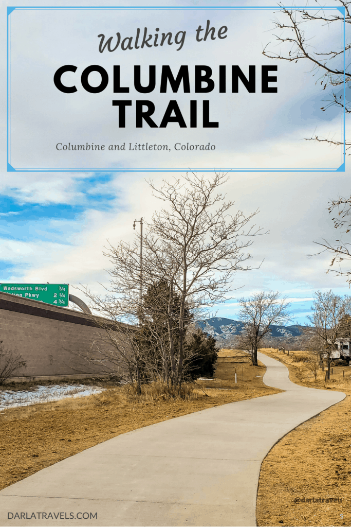
The Columbine Trail on the border of the Columbine suburb and Littleton, Colorado, is a convenient hard surface trail. This no-frills walkway is easy to get to and easy to navigate. With one trailhead, few intersecting trails, and a simple route, the chances of getting lost or taking a wrong turn are close to nothing. At 4.2 miles (6.8 km) one way, this practical trail will scratch the itch to get out for a walk, as long as scenery and nature aren’t a top priority.
About the Columbine Trail
There is more than one Columbine Trail in this area (and in this state), so pick the right one. Two different organizations manage this Columbine Trail. The South Suburban Parks and Recreation District (SSPRD) is responsible for about 2.6 miles (4.1 km), with the Foothills Park & Recreation District (FHPRD) overseeing a shorter portion of another 1.6 miles (2.6 km). Don’t confuse it with a private trail of the same name in the nearby Ken-Caryl Ranch Open Space.
The sole trailhead for the Columbine Trail is near the southwest corner of the intersection of S Platte Canyon Road and W Bowles Ave in Littleton, Colorado. Just minutes from Santa Fe Drive (Highway 85) or Highway C470, it’s easy to get there. Although the parking lot is small (16 spots), it’s adequate for the amount of use it gets. The path parallels S Platte Canyon Road on a southwest/northeast line, and when the road turns and becomes Chatfield Avenue (east/west), the trail continues. See the custom map below for more details.
This trail parallels a busy road in a suburban area and, frankly, does not have the best scenery. If immersion in nature and a quiet environment are crucial, it might be best to look for another trail.
If you want scenery and nature, I’d recommend heading to the nearby South Platte Park to walk on the Mary Carter Greenway, following the South Platte River. The access road to South Platte Park is only 2.7 miles (4.3 km) south of the Columbine Trail trailhead on S. Platte Canyon Road.
On the other hand, positives include:
- There are generally few people on the Columbine Trail.
- It’s long enough for a substantial walk, about 8.4 miles (13.6 km) round trip.
- The flat, paved surface makes for easy walking.
I have to admit, I drove on Platte Canyon Road alongside the Columbine Trail endless times before it occurred to me to walk on it, as I didn’t realize it was a named trail. After it was repaired and upgraded in 2020, I decided it was time to give the Columbine Trail a try. It was perfect for a walk on a day where I wanted something different but didn’t want to drive too far.
Walking the Columbine Trail

From the trailhead on S Platte Canyon Road, there is no reason to go north, as the end of the trail is only about 187 feet (57 m) away at Bowles Ave.
Well, there might be one reason to go north: to look for a restroom.
With no restrooms at the trailhead or anywhere along the trail, the main restroom options are at the corner of Bowles Ave and S Platte Canyon.
- Wynetka Ponds Park on the northwest corner of the intersection has a portable restroom.
- A strip mall including a gas station at the southeast corner likely is another option if you arrive during business hours.
- Finally, there is another strip mall on the northeast corner, slightly further away
The only other possibility for a restroom on the trail is a strip mall at the intersection of S Platte Canyon and W Mineral Ave (southeast corner), about 2.2 miles (3.5 km) south. See the custom map below for more location information.
Now that that the tour of this intersection is complete, it’s time to turn around and head south.
The North/South Part of the Columbine Trail
Starting from the trailhead, houses and housing developments are the main scenery, and most are fenced or walled off from the path. Many of the older neighborhoods have mature trees, but they are too far away for any shade. Some of the adjacent properties have horses, which are nice to see in an area with increasing development.
The trail has multiple covered benches, each of which has its own ultra-large trash can. Given the light use of this trail, I’m not sure why there are so many of these and no restroom at all, but it’s good to know you can sit and take a break at regular intervals if you’d like.

The trail crosses over waterways Dutch Creek and Massey Draw and passes by a few ponds. A country club golf course and church round the most interesting sights, which isn’t saying much.
This trail’s location makes it difficult to see mountains to the west. They are visible to the south, but I’d consider these views average at best.

The East/West Part of the Columbine Trail
The walk takes on a different feel south of its intersection with the Massey Draw Trail (about 2.8 miles, 4.5 km), where it begins to turn toward the east. At this point, the trail management changes from SSPRD to FHPRD. There are better views of the mountains, but a storage unit facility on the other side of the street doesn’t appeal. At this point, the trail feels no different than an ordinary sidewalk and continues as such past a roundabout and along Chatfield Ave.
On Chatfield Ave, a well-marked pedestrian crosswalk comes into view, and the trail continues on the other side of this crosswalk. It’s easy to wonder where the path is going since it appears to literally hit a wall, the wall that blocks the view and noise of highway C470. But the trail does keep going parallel to the wall, behind a residential neighborhood.


Past the end of the wall, a view awaits that makes this eccentric trek seem worth it. Above the highway, there are unrestricted views of the Front Range of the Rocky Mountains from north to south. Across the highway, Chatfield Lake shimmers and the red rock formations of Roxborough State Park can be seen in the distance. Still, the highway noise can be a distraction from the otherwise peaceful environment.

The trail ends just past a tunnel that goes under the highway and to the C470 trail. At this juncture, a dirt path traverses the adjacent field to the right, connecting to nearby neighborhoods. Here, I took a good look at the mountains before turning around and heading back to the start.

Precautions on the Trail

The majority of this trail runs parallel to a busy street. Even though cars were passing by on Platte Canyon Road, I was far enough away to feel safe, thanks to a grass buffer separating the trail from the street.
Following parallel to the road, the trail crosses several intersections, some with traffic lights and some without. It’s essential to keep an eye on the traffic and obey any crosswalk signals. I’d also recommend wearing reflective or otherwise visible clothing for extra safety.
As mentioned above, there are no restrooms along this trail, so plan accordingly.
Finally, there is no shade on the majority of this trail, and it can heat up quickly on sunny days. Be sure to have adequate sun protection (hat, sunscreen, sunglasses) and carry water.
Trail connections
Trail connections are shown on the custom map below. As I noted above, the Columbine Trail passes over Massey Draw. At that point, it intersects with the Massey Draw Regional Trail, a 1.5-mile paved trail on a generally east/west line.
At the end of the Columbine Trail, passing under highway C470 puts you in Chatfield State Park and on the C-470 Trail, which runs next to the highway.
Two other connections to the Columbine Trail are worth mentioning. The first is the sidewalk along Coal Mine Avenue, which is considered a “multi-use path.” The second is the sidewalk along Mineral Ave. This sidewalk is a named trail under the care of SSPRD, the Railroad Spur / Mineral Avenue Trail. It connects to the Mary Carter Greenway and further away, to the High Line Canal Trail.
Custom Map of The Columbine Trail
I created this map on AllTrails to summarize everything you need to know about the Columbine Trail.
Legend:
Red: Columbine Trail
Blue: Connectors or neighborhood access
Yellow: Waypoints/Trailheads
Don’t see the map or want to see the original? Click here to go to the map page on AllTrails.
Other Trail Information
| Distance | 4.2 mile (6.8 km) |
| Difficulty | Easy |
| Trail Type | Point-to-point |
| Trail Surface | Asphalt, concrete |
| Besides Walking: | Running, biking |
| Links | SSPRD interactive map SSPRD printable district map Colorado Trail Explorer (COTREX) Page |
| Closest Towns | Littleton, Columbine |
Wrapping up the Columbine Trail
Perhaps one of the best things about the Columbine Trail is its light use. There will be plenty of cars zipping by, but generally, this path is unpopulated. If you’re feeling introverted or just want some time alone, the Columbine Trail is a good option; this paved trail is wide enough to avoid any cyclists or the occasional neighborhood dogwalker.
To be sure, most of the views from the Columbine Trail aren’t incredible, but the round trip is a respectable distance of 8.4 miles (13.6 km). It’s a practical route, delivering functionality without fanfare.
Would you walk on the Columbine Trail? Leave a comment below!
The Columbine trail from you description, looks like a great place for walking and hiking. I’d like to see Chatfield Reservoir. It’s surprising that the trail is not crowded and provides some solitude. Nice views at the end of the trail make it worth hiking.
Glad you liked it!
You might be a little harsh on this trail. I think for someone visiting the area from a more urban location this would be awesome. It looks like an easy walk and there is some pretty mountainous scenery.
That’s a good point! And for someone not used to the altitude, this trail could serve as a place to test the effects of the thinner air here.