** Darla Travels is reader-supported.
When you buy through our links, we may earn a commission. **

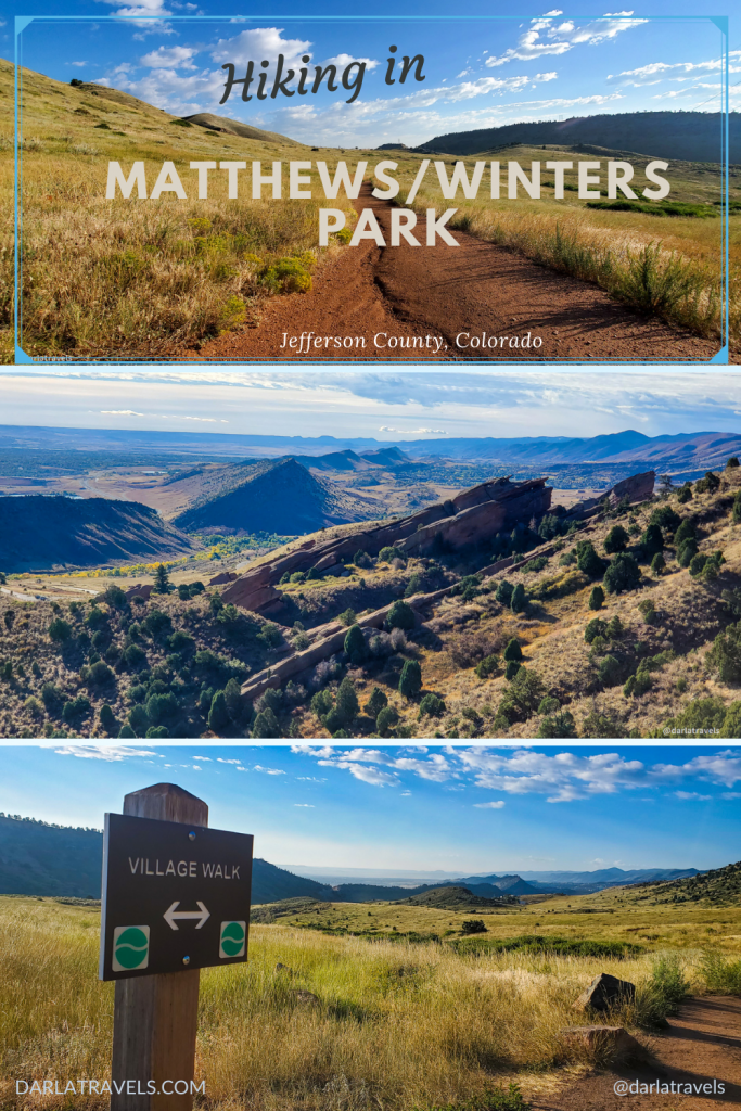
The trails in Matthews/Winters Park pass through the remnants of the 1860’s settlement of Mount Vernon, wind around ancient red rock formations, and traverse the geologically significant Dakota Hogback. There is so much to say about hiking in Matthews/Winters Park that one post isn’t enough.
This Part 1 post will describe hiking in Matthews/Winters Park west of Highway 93, near Golden and Morrison, Colorado, which covers land from the former settlement of Mount Vernon.
Part 2 covers the Dakota Hogback on the eastern side of the park. Click here to be taken to Part 2.
Getting back to the post at hand, let’s start with the town of Mount Vernon, which prospered for only a short time. Matthews/Winters Park now preserves the land the town once occupied, as well as its history, and all adjacent to stunning red rock formations.
Sound interesting? Read on to learn more about hiking in the western park of Matthews/Winters Park.
About Matthews/Winters Park
Matthews/Winters Park is one of the Jefferson County Open Space (JCOS) parks. This 2,461-acre (995-hectare) park is bordered by Interstate-70 to the north and Denver’s Red Rocks Park to the south. Most of the western part of the park covers a parcel of land that was once the town of Mount Vernon, and the eastern part contains the Dakota Hogback geological feature.
The Mount Vernon Townsite
When gold was discovered in the mountains, an enterprising Mount Vernon resident built a toll road from Denver through the town and up the canyon. With the increased traffic from gold seekers, the municipality and its businesses began to grow. At that time, the town was part of the Jefferson Territory, and its governor was also a Mount Vernon resident.
The Jefferson Territory lost political power after the federal government recognized the Colorado Territory in 1861. Around the same time, new companies created more reliable toll roads in other locations. As a result, Mount Vernon’s heyday was over in two short years. The population declined further when railroads also chose other canyons as building sites.

The park gets its name from two families that contributed land to JCOS. The last residents of Mount Vernon were William Matthews and his family. Matthews acquired two historic stone houses, as well as additional plots from the Mount Vernon ghost town. The historic homes, now on private property, were threatened when the construction of Interstate 70 in Mount Vernon Canyon was proposed starting in the 1950s.
Developers targeted other nearby lands for commercial and residential purposes. William and Joan Winters purchased and then sold this land to Jefferson County Open Space so it could be preserved. Later on, JCOS bought additional land from a descendent of William Matthews to complete the park.
Hiking in Matthews/Winters Park (western section)
Within the park are 12.2 miles (19.6 km) of trails. The park entrance, parking lot, and trailhead are off of Highway 93, just south of I-70. See the custom map below for the location, as well as other parking access.
Near the trailhead
From the parking lot, the Village Walk trail heads toward tall cottonwood trees lining Mount Vernon Creek. Before the creek crossing, note the restroom buildings on the west side and a creekside picnic area on the east. The Village Ride trail also heads off to the east.
Village Walk and Village Ride trails form a loop. Therefore, I’ll recommend taking Village Walk on the way out, and returning on Village Ride for the reasons explained below.

Catch a glimpse of the Mount Vernon House from the Village Walk trail once you cross over the creek and take a slight uphill into an open grassy meadow. The Mount Vernon House, one of the two remaining structures from the town of Mount Vernon, is just outside the park on private property. While it’s been substantially expanded and upgraded since its construction, the original stone walls are still visible. It’s included on the National Register of Historic Places.
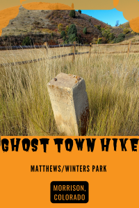
Continuing on the Village Walk soon brings you to one of the park’s unique features in approximately 1/8 of a mile (643 ft, 1,900m): the ruins of the Mount Vernon cemetery. It would be easy to miss without knowing the location, but a sign and fencing preserve the few headstones that remain.

Unfortunately, the plot is overgrown with tall grass. Nonetheless, there is enough here to get a sense of the history and heritage of this now-vanished town.

The short walk to the cemetery might be enough to satisfy the curious ghost town enthusiast. But if continuing further into the park, it’s a warm-up for the remaining hike. So, back on the path, continue ahead on the trail, now named Red Rocks. Close to this point, there is also an intersection with the Village Ride trail, which will take you back to the start in 0.3 miles (0.5 km).
The Red Rocks Trail and Cherry Gulch Loop
Although the trail name changes to Red Rocks, the environment is the same: open meadow with tall grass and foothills sloping up rather steeply to the west. The Dakota Hogback is to the east, blocking the view of the metro area on its far side.
After about 0.4 miles (0.6 km), there’s a fork in the trail. Take either direction, as the Red Rocks Trail and the Cherry Gulch trail form a loop. The Cherry Gulch Trail is rated difficult and marked with a black diamond. This trail descends steeply with a hairpin-like turn to cross over the namesake Cherry Gulch. But at only 0.3 miles (0.5 km), it’s doable. The entire loop is about 1.1 miles (1.8 km).

This loop has two forks. The first is a continuation of the Red Rocks Trail, and the second is the Morrison Slide Trail. These two branches form yet another loop, and unless you’re ready to return to the trailhead, I’ll recommend continuing to the Morrison Slide.
Morrison Slide
Morrison Slide heads uphill for 1.5 miles (2.4 km). With multiple switchbacks, it’s strenuous but manageable for most reasonably fit people. Mountain bikers call it “challenging.” Better views reveal themselves as the elevation increases, with an excellent perspective at the high point.
Even better, as the trail moves closer to Denver’s famous Red Rocks Park and amphitheater, red sandstone rock formations will awe trail-goers. Part of the Fountain Formation, this rock layer was pushed up and tilted as the Rocky Mountains emerged. Over time, it has eroded into the impressive forms jutting from the landscape today.

At the far point of the trail, the name changes back to the Red Rocks Trail at a fork. One branch of the trail returns toward the trailhead, and the other descends into the neighboring Red Rocks Park.
Other Information for Matthews/Winters Park
Matthews/Winters Park trailhead has a 58-spot parking lot. Check the Lot Spot app for current parking availability. Also, see the map below for other nearby parking lots. Unfortunately, there are no water sources or electricity at this trailhead, but as mentioned above, there are restrooms and a picnic area.
Additionally, this park is a favorite for mountain bikers. Stay aware of your surroundings and practice good trail etiquette with all trail users, whether on foot or on two wheels.

One of the drawbacks of hiking here is the proximity to I-70. The highway noise detracts from what would otherwise be a peaceful natural area; however, the noise diminishes somewhat as the hike moves further away from the freeway.
Be cautious of snakes, including rattlesnakes, that call Matthews/Winters park home. On my recent visits, signs warned of rattlesnake activity.
A few simple safety practices can go a long way toward avoiding unpleasant encounters with rattlesnakes.
- Wear appropriate footwear, including closed-toed shoes and thick socks.
- Stick to the trails and avoid stepping in grasses or weeds where snakes may be hiding.
- Be mindful of the environment: watch the trail, and if listening to headphones, keep one ear open to hear the reptile’s signature warning rattle.
- If you encounter a snake, apply the “30-30” rule: keep 30 feet (9 m) away for 30 seconds to allow the snake to move off the trail.
- If the snake doesn’t move, be patient. Then, consider if it is possible to walk around the snake with enough space to maintain safety.
- Rattlesnakes are generally not aggressive, but they may react defensively if provoked by being prodded with a stick or thrown rock.
- Keep dogs on a leash and don’t allow them to explore brush or rocks where snakes may be hiding.
- If bitten, keep calm and minimize movement. Have a working knowledge of venomous snake first aid for you and your dog.

Finally, the usual precautions apply for Colorado Front Range hiking.
- There is little shade in this park, so appropriate sun safeguards in the form of a hat, sunglasses, protective clothing, and sunscreen, are a must.
- Always bring adequate amounts of water for the dry climate.
- Check the weather forecast and reschedule your visit if rain or thunderstorms are forecast.
Trail connections
Matthews/Winters Park trails connect to the adjacent Red Rocks Park via the Red Rocks Trail. (And on the other side of Red Rocks Park, access another Jefferson County Park, Mount Falcon Park) As explained above, at the southern end of the Morrison Slide/Red Rocks Trail loop, the Red Rocks Trail returns to the trailhead or continues to Red Rocks Park.

Custom Map of Matthews/Winters Park-Western Side
These hikes have the trailheads and points of interest marked.
Don’t see the map or want to see the original? Click here to go to the map page on AllTrails.
Other Park Information
| Getting There | 1103 County Highway 93 Golden, CO 80401 |
| Distance | Total of 11.9 miles (19.2 km) of trails. |
| Difficulty | Easy to moderate, Morrison Slide is more difficult |
| Trail Type | Out and back, with a few loops along the way |
| Trail Surface | Unpaved, natural |
| Besides Hiking: | trail running, mountain biking, equestrian |
| Links | Jefferson County Open Space Park System Map JeffCo Open Space Page Colorado Trail Explorer (COTREX) Page AllTrails page for Matthews/Winters Park |
| Closest Towns | Morrison, Golden |
Hiking in Matthews/Winters Park traces a landscape with multiple historical and geological interests. In the western part of the park, meadows that once supported the now-vanished town of Mount Vernon have reverted to their natural state. Deeper into the park, trails climb to provide stunning views of red rock formations shaped by geological processes that occurred millions of years ago.
Pin it for Later
Here are a couple of pins for your Pinterest Boards
Where have you gone hiking in Matthews/Winters Park? What did you think? Leave a comment below!
Love JEFCO open space and one of the many things I miss about living in CO!
Matthews/ Winters Park is a very interesting place for hikers and for lovers of nature, history, and photography. We would be interested to see old stone houses, to walk trough the old cemetery, and then to hike to the top of the Fountain Formation for great views. Thank you for sharing this network of beautiful trails, photos, and the map.
Glad you enjoyed it!
So the only Ghost Town I have ever been to was Bodie, California and it was crazy to see all the buildings, homes, and leftover mining facilities that were just left forever.
But it doesnt seem like much of that is left in Mount Vernon. So to me this feels like a pretty beautiful epic hike cause I love all the Red Rock formations and those views are wonderful. It is pretty cool that you found the old cemetery with a few headstones left. That would be cool to hike to and discover.
The only drawback of this whole Matthews Winter Park Experience….Rattle Snakes.
Fortunately, the cemetery is easy to find. Rattlesnakes are pretty common in this area, but, again, fortunately, they don’t show themselves too often!
Nice landscapes!
It looks like a hike I would enjoy!
Thank you!
Glad you enjoyed this post!
Your photos do a great sense of capturing the vastness of the landscape. Looks like a great place to explore. I especially like old cemeteries, so this would have been right up my alley!
Thank you! I hope you get a chance to visit someday.
How interesting to find such a town. It’s heyday really ended in two years? It’s hard to imagine its population declining in such a short time.
Love the landscapes though, beautiful. 🙂
Glad you enjoyed it!
So cool that you can see the beautiful Red Rocks Amphitheatre from the hike. Is the name of the town related to George Washington at all?
The town was named after George Washington’s Mount Vernon! Thanks for visiting!