** Darla Travels is reader-supported.
When you buy through our links, we may earn a commission. **

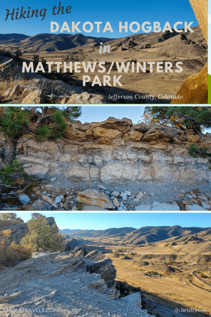
Hiking up and across the Dakota Hogback on the east side of Matthews/Winters Park provides a good climb, views for miles, and a rocky route along an ancient ridge. This hike is so different from the trails in the western part of the park that I’ve dedicated a whole post to it in this Part 2 on hiking in Matthews/Winters Park.
To learn more about the trails in the western part of the park, which cover the Mount Vernon ghost town and red sandstone rock formations, see the Matthews/Winters Park Part 1 post.
To learn more about hiking the Dakota Hogback in Matthews/Winters Park, keep reading.
About Matthews/Winters Park
Matthews/Winters Park is a Jefferson County Open Space (JCOS) park with land on either side of Highway 93 near Morrison and Golden, Colorado. At the foothills of the Rocky Mountain Front Range, this open space manages to include a ghost town, geologically significant rock formations, a raptor watch site, and a rich source of dinosaur fossils.
The trails in the western part of the park cut through meadows near the ghost town of Mount Vernon, with a stop at the town’s abandoned cemetery. Climbing on the Morrison Slide opens up views of red rock formations shaped by geological processes that formed the Rocky Mountains millions of years ago. For more on these trails, click here.
Matthews/Winters Park additionally includes part of the Dakota Hogback, also a Colorado State Natural Area, and the subject of this post.
I’ve noticed that maps refer to parts of the Dakota Hogback as “North Dinosaur Park” and similar names, but the land is now part of Matthews/Winters Park.
The Dakota Hogback
Why is it called a hogback? in geological terms, a hogback is a ridge with a sharp summit and steeply sloping sides. A hogback is formed when layers of sedimentary rock are pushed up and tilted by geological forces.

The Dakota Hogback formed around 50-70 million years ago and has multiple sedimentary rock layers within its steep outcroppings. The topmost layer of hard Dakota Sandstone protects the softer layers underneath from erosion. This tilting ridge serves as the border between the Great Plains and the foothills of the Rocky Mountains.
To be sure, only a tiny part of the Dakota Hogback is within Matthews/Winters Park. The full hogback is several hundred miles (km) long, extending out of Colorado and into the neighboring states of Wyoming and New Mexico.
Dinosaur Ridge
The Dakota Hogback is also referred to as Dinosaur Ridge.
Naturalist Arthur Lakes discovered dinosaur bones on the hogback starting in 1877, including the first instances of Stegosaurus, Apatosaurus, and Diplodocus. Considered one of the best sites of dinosaur fossil preservation in the country, the Dakota Hogback is also a National Natural Landmark under the name Morrison-Golden Fossil Areas.

Several interpretive exhibits line the single road (Alameda Parkway) climbing over the hogback. Dinosaur footprints, bones, and interesting geological features are highlighted. In addition, the non-profit Dinosaur Ridge organization visitor center at the foot of the hogback provides both walking and bus tours of the ridge fossil areas.
Raptor Migration Observation
The Dakota Hogback’s unique features make it something of a superhighway for raptors, especially in the spring migration.
Wind blowing over the ridgeline of the Dakota Hogback creates lift, and heated air from the ground rises in thermal updrafts simultaneously. Together, these phenomena allow birds of prey to quickly fly higher and coast or soar near the hogback with their wings outstretched, conserving energy.

At a “HawkWatch” site at the north end of the hogback, volunteers collect data on the type and number of raptors coming through the area. The information from these citizen scientists is included in a national public database monitoring raptor populations.
For information on volunteering, contact the coordinating organization, Denver Field Ornithologists.
Hiking the Dakota Hogback in Matthews/Winters Park
For restroom access, go to the main park entrance off Highway 93, just south of I-70. From here, a sidewalk leads to a crosswalk over Highway 93 to pick up the Dakota Ridge Trail.
Alternatively, park in the Stegosaurus parking lot on the hogback side of Highway 93 just north of the park entrance for a quick start. See the custom map below for location information.
The Dakota Ridge Trail
Caution: Note that this trail is rated as “difficult” and marked with a black diamond!
Whether starting from the trailhead or the Stegosaurus lot, the steep slope of the hogback means the only path is uphill. So don’t be surprised to feel the burn on this climb. The sharp part of the slope took me about 7 minutes to complete. At that point, it’s still uphill, but at a much gentler grade.
Trail signs point toward the raptor observation site at the top of the hogback and just to the left (north).
The Dakota Ridge Trail continues to the right (south) for about 2.2 miles (3.5 km). The dirt path passes through pine trees and junipers. It opens up in a grassy meadow with excellent views, including Green Mountain to the east.

Past this meadow, the trail becomes much more difficult. The path is rocky, with many uneven surfaces. Be ready to step up, on, over, and around sometimes sizeable rocks on the course. At the same time, the trail is covered with fine sand of eroded Dakota Shale, which can be slippery. The trail width ranges from narrow to “not very wide.” At times, the path requires stepping somewhat close (in my opinion) to steep dropoffs.
However, this slow and challenging walk is made worthwhile by the various rocks and rock layers covering and lining the trail.

My GPS recorded a total climb of 587 feet (179 m). Because the ridge is steep and narrow, the elevation means views go for miles in all directions, another benefit of this route.

After 2.2 miles (3.5 km), the Arthur Lakes Lookout provides impressive views. Just past the lookout, the trail descends to the asphalt-covered Alameda Parkway. The road is well-marked with lanes for pedestrians and cyclists. The only vehicles allowed on Alameda are tour buses with sightseers from the Dinosaur Ridge Visitor Center, so it’s pretty safe.

Follow the signs and walk along the road a short distance to a lookout with park information. Just past this lookout, a sign points the way to the rest of the unpaved Dakota Ridge Trail.
Beyond Alameda Parkway, the Dakota Ridge Trail continues for about 0.3 miles (0.5 km). This is the end of the line for hikers, as here, the trail name changes to Dakota Ridge South Trail, a bike-only trail.
Fossil Hunting on Dinosaur Ridge
On the other hand, the smooth pavement of Alameda Parkway may be a welcome relief after the rugged terrain along the Dakota Ridge Trail. It’s safe and easy to walk to the roadside exhibits with preserved dinosaur tracks and fossilized dinosaur bones. The parkway is not too steep, and the displays are well-marked, making it a good excuse to take a break from the more rigorous trail.

Alameda intersects Highway 93 on the western side of the hogback. It’s possible to continue walking along the highway back to the parking lots; however, this cannot be recommended for safety reasons.
Dakota Hogback Trail connections
Besides the start at the Stegosaurus Lot, a few trails branching from the Dakota Ridge Trail provide alternate routes up and down the hogback. Two forks from the trail south of Alameda Parkway allow descent of the hogback to Highway 93 and the entrance to Red Rocks Park (Red Rocks and Bail Out Trails, each 0.4 miles ((0.6 km)).
From the northern section of the Dakota Ridge Trail, the Zorro Trail descends toward the east down to the Rooney Road trailhead and parking lot. This trail then crosses highway C-470 to connect to the C-470 Trail and the trails on Green Mountain.

Hiking the Dakota Hogback in Matthews/Winters Park – Custom Map
I put location information for hiking the Dakota Hogback in the custom AllTrails map below.
Don’t see the map or want to see the original? Click here to go to the map pages on AllTrails.
Other Trail Information
| Getting There | Stegosaurus Lot: State Hwy 26, Golden, CO 80401It’s just north of the main trailhead and parking at 1103 County Highway 93Golden, CO 80401 |
| Distance | 0.3 mile (0.5 km) climb to the HawkWatch site 2.6 miles (4.25 km) on the Dakota Ridge Trail |
| Difficulty | Difficult! Steep climb to the top of Dakota Hogback and a narrow rocky path along the ridge. |
| Trail Type | Out and back, with a few different trails descending off of the hogback. |
| Trail Surface | Unpaved, natural |
| Besides Hiking: | trail running, mountain biking |
| Links | Jefferson County Open Space Park System Map JeffCo Open Space Page Colorado Trail Explorer (COTREX) Page AllTrails page for Matthews/Winters Park |
| Closest Towns | Morrison, Golden |
Conclusion
Hiking the Dakota Hogback in Matthews/Winters Park starts with a steep climb to a narrow ridge, followed by a challenging, rocky trail that can be pretty narrow. But, while arduous, the effort pays off with 360° views, intriguing rock layers, and even dinosaur fossils.
Pin it for later!
Have you hiked the Dakota Hogback? What did you think? Leave a comment below!
Okay, this is seriously cool. I love the unique geology . . . and you got to see dinosaur bones?! Sounds like a challenging, but rewarding hike.
Yes, exactly! Glad you enjoyed the post.
Such a beautiful landscape and structure of the surface <3 would love to visit…
Glad you liked the post!
This sounds interesting, I mean with dinosaur fossils and all, but also rather challenging. I typically stay away from the more challenging stuff because I have a habit of falling on my face even on flat surfaces. lol
Oh no! You could always take the bus tour to see the fossils if you are worried about falling.
Actually it not that steep for long. Then you go down till you get to the intersection of the Zorro Trail. But continue to climb up and it’s a little steep but once you get to the top it’s all downhill to the wooden bridge to the Dinosaur Tracks!!! If you are tired you can walk down highway 40 and bypass the trail you came on or go down past Dinosaur Ridge and take the road back up to eventually Colfax. A good place to stop to eat is Wrigley s field a sportsbar at 18500 W Colfax with good but reasonable priced food!!! If you go up the back parking lot hill there is a soccer field and off to the side the Stegosaur Trail up an easy gentle ridge back to where you started!!! So you cut out lots of climbing!!!
Thanks for your comment! Your route takes you out of the park and I haven’t been that way, but I’m putting it on my “to do” list.