** Darla Travels is reader-supported.
When you buy through our links, we may earn a commission. **

At the Sulphur Gulch Trail on a sunny winter morning, the air was chilly yet invigorating. The clear skies and bright sunlight, welcome on a cold winter day, could become overwhelming in the summer when temperatures can soar to over ninety degrees Fahrenheit (32C). The Sulphur Gulch Trail, flat and with little shade, wouldn’t appeal to me in such hot conditions, but it was ideal for below-freezing weather. The paved Sulphur Gulch Trail was also a good choice for a post-snowfall walk since ice and snow disappear quickly in strong sunlight. Cyclists frequent this trail, but I didn’t encounter any in the middle of the winter, another reason to try this trail in cold weather. This long weekend walk was over 11 miles total (17.9 km). For more on the Sulphur Gulch Trail, keep reading.
The trial is an approximately 4.5-mile (7.4-km) long paved path that runs primarily east-west through Parker, Colorado, following Sulphur Gulch. At the end of the official trail, the surface turns to dirt and continues to the south. I’ll cover both the paved and the natural surface trail segments in this post. The combined one-way distance for both sections of the trail is 5.8 miles (9.4 km), with an elevation change of only 433 feet (132 m) over the entire distance. The trek itself won’t be strenuous, but the long mileage is conducive to building endurance.

Parker is in Douglas County, about 20 miles (32 km) southwest of Denver. Settlement here started in the mid-1860s. First known as Pine Gulch, it was named Parker in 1882 after two brothers developing the area. Parker has seen explosive growth recently and has become a popular commuter base for Denver. (The population was 5,450 in 1990, and today is over 60,000!)
Parker now has over 30 miles (48.3 km) of trails (concrete and soft surface) along with over 1,250 acres (506 hectares) of open space and developed parks.
The Sulphur Gulch Trail is, at least for now, the longest of these trails. To travel from west to east on the Sulphur Gulch Trail, start at the trailhead at Bar CCC Park off S Twenty Mile Rd. (Pro tip: don’t just search “Bar CCC Park” in your map app; it may take you to a nearby neighborhood but not Twenty Mile Rd.)
This trailhead has a large dirt parking lot with plenty of spaces. A portable restroom is just off the trail to the west. Other places to access this trail in Parker include Town Hall, Discovery Park, and Paperflower Park. For details, see the custom map below.
Walking The Sulphur Gulch Trail
Once on the trail, head east and cross beneath S Twenty Mile Rd. There is plenty of open space around the creek, with apartment buildings visible above the banks. This location is also retail-heavy, yet the big box stores and shopping centers are not too prominent.
At the intersection with S. Pikes Peak Road, a well-marked crosswalk continues the trail. A glance down the road reveals some thoughtful development with the feel of a small-town main street.

History
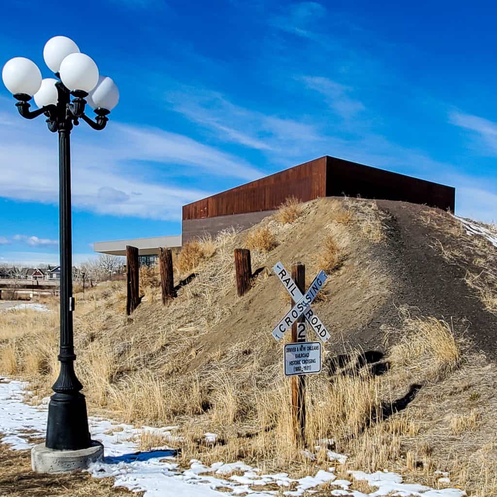
The trail passes through the heart of Parker, nest to the Parker Arts, Culture & Events (PACE) Center, an outdoor recreation station, and the modern Parker Town Hall. At the PACE Center, look for what’s left of the Denver & New Orleans Railroad crossing over Sulphur Gulch. The track was laid starting in 1881, and the train ran from Denver to Pueblo, Colorado, beginning in 1882. After a competing rail company had siphoned off most traffic and a devastating flood caused extensive damage to part of the line, it was abandoned. The tracks were removed in 1936.
As the trail continues east, the tree-lined gulch is always in view, along with the surrounding open space filled with prairie grass. Keep an eye out for wildlife–I saw a group of deer in the trees along the water on my winter day hike. With the trail following a path relatively parallel to Parker’s Mainstreet, civilization is never far in the distance. Schools, parks, and street crossings approach in rapid succession. See the custom map below for waypoints with amenities.
One fun surprise was a beautiful mural in the underpass at Willow Park Drive, entitled “Love Others” and signed “Lutheran HS.”

Further east on the trail, houses get closer in, but the green space is still abundant.
The trail takes a ninety-degree turn down a short hill to the south at the edge of the town even though the Sulphur Gulch waterway continues out to the east.
This north/south segment is about 0.3 miles (450 m), and a sign warns of the trail end. The pavement turns back to the west, but a natural surface trail continues to the south.
Don’t Stop Now
Paperflower Park (parking and restrooms available) is about 650 feet (200 m) ahead on the paved path at this fork in the road.
The dirt trail now follows along a different, smaller watercourse, Sara’s Gulch.
To the east, the landscape shifts. Typical suburban subdivisions are absent. There is more of a country feel, with large (sometimes very large) houses on large lots dotting the rolling hills.
Looking west, find some marvelous views of the Rocky Mountains in the distance on this stretch of the trail.

The trail crosses Bufflaloberry Dr and continues south. At this intersection, the small parking lot and shelter to the right is Spirit Ridge Park. The path becomes more of a sidewalk as it begins to follow along Sara Gulch Cir. According to AllTrails, the trail ends at the intersection of Sara Gulch Cir and Canyon Wind St (unmarked) that I found tagged “Private Property.” It is possible to continue along Sara Gulch Cir, but I chose to stop at this point and return to the start.
Trail connections
There are two primary trail connections from the Sulphur Gulch Trail.
As Sulphur Gulch is a tributary of Cherry Creek, it’s not surprising that the trail start is its intersection with the Cherry Creek Regional Trail. This intersection is about 650 feet (200 m) west of the trailhead at S. Twenty Mile Rd. The Cherry Creek Regional Trail is a 40+-mile (64+-km) paved path popular for recreation, especially with cyclists, many of who commute to downtown Denver on weekdays.
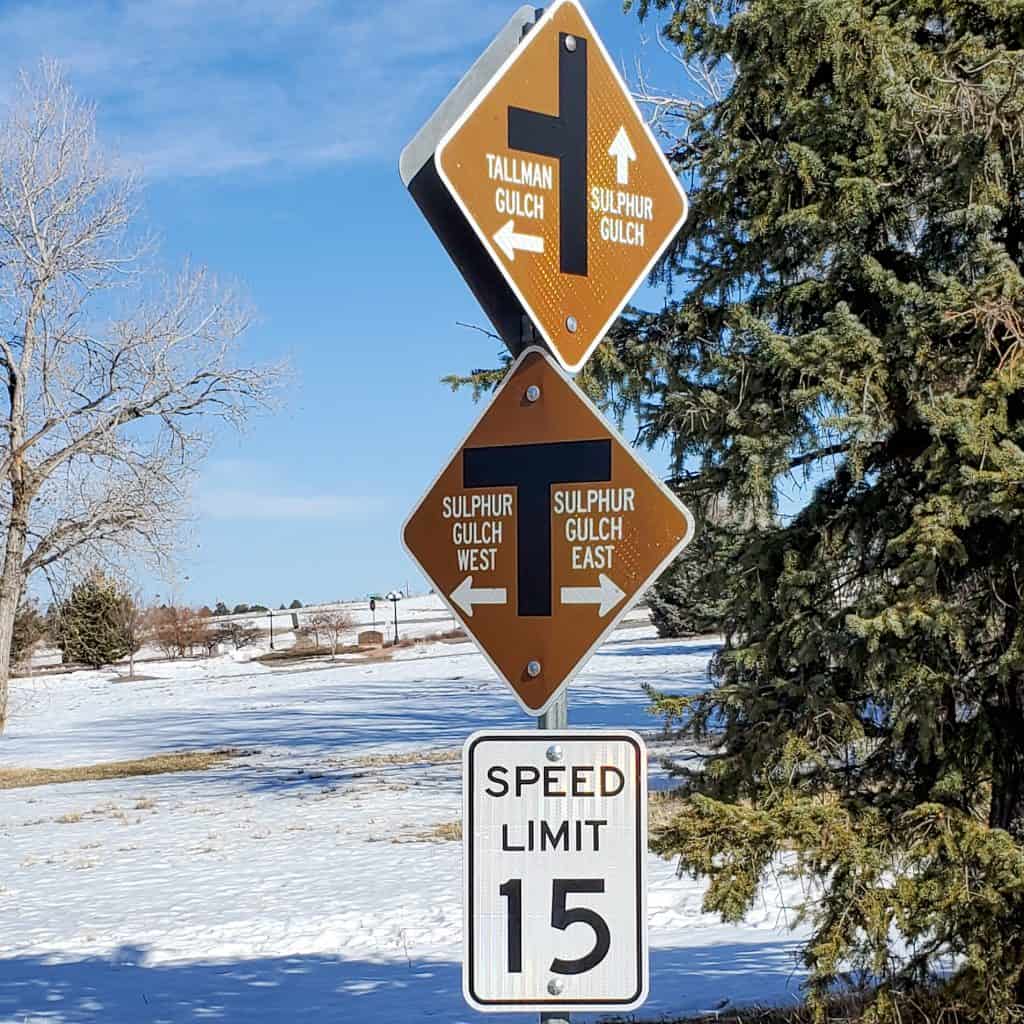
At Stonehenge Way, the Sulphur Gulch Trail connects to another Parker Parks and Rec trail, the Tallman Gulch Trail (3 miles, 4.8 km), which goes through Parker and ends at the southeast corner of town near Tallman Meadow Park.
Custom Map of The Sulphur Gulch Trail
I created this map on AllTrails to summarize all of the access information on The Sulphur Gulch Trail in this post.
Legend:
Red: Sulphur Gulch Trail
Blue: Connectors or neighborhood access
Purple: trail extension
Yellow: Waypoints/Trailheads
Don’t see the map or want to see the original? Click here to go to the map page on AllTrails.
Other Trail Information
| Distance | Official Trail: 4.6 miles (7.4 km) one way Extension: 1.2 miles (2 km) Total: 5.8 miles (9.4 km) |
| Difficulty | Easy (total elevation gain: 433 feet, 132 m) |
| Trail Type | Out and back |
| Trail Surface | Main Trail: paved Extension: natural surface |
| Besides Walking: | Running, cycling |
| Links | Parker Parks and Rec Interactive Trail Map Parker Parks and Rec Trail Page Colorado Trail Explorer (COTREX) Page |
| Closest Towns | Parker |
Conclusion
The suburban Sulphur Gulch Trail provides an insight into Parker, Colorado. Passing by and through housing developments, retail centers, and government and cultural buildings, it never strays far from open space and its namesake creek. On the eastern edge of Parker, past the trail’s official end, the lower population density translates to excellent views of country homes and the mountains. With little shade, it’s a worthy choice for a suburban walk on a winter day.
Would you walk the Sulphur Gulch Trail? Leave a comment below!
Pin it for later!

This looks like such a cool suburban trail. I love how well signed it is and that view of the Rockies is stunning! Sounds like you had a great winter hike!
I wasn’t sure what to expect but, yes, it was a very nice suburban hike.
Darla,
You find the coolest trails. The town I live has a plan for another 64 miles of trail, just need money to build it. We have about 10 now.
That’s exciting but waiting is hard! I’d love to come and check the new trails when they get built.
You’ve given me some new places to visit when in Denver. Thanks!
Roxie, thanks for reading!