
** Darla Travels is reader-supported.
When you buy through our links, we may earn a commission. **
Make Scottsbluff, Nebraska, your home base for a weekend getaway to historical sites sprinkled with short and easy to moderate hikes. In this post, I’ll suggest four different walking excursions within Scottsbluff and nearby that will keep you engaged during a long weekend.
About Scottsbluff, Nebraska
The greater Scottsbluff area, which includes Gering and Terrytown, is home to about 24,000 people. It might be easy to overlook a small city far from a major interstate, but that would be a mistake. There’s plenty to do here in the “Sugar Valley” of the Nebraska panhandle, without the crowds of bigger cities and at a relaxed pace.
Approximate drive times to Scottsbluff are as follows:
- Denver, Colorado, 3.5 hours
- Cheyenne, Wyoming, 1.5 hours
- Rapid City, South Dakota, 3 hours
- Omaha, Nebraska, 6.75 hours

If coming from further away, consider a flight to the Western Nebraska Regional Airport just east of Scottsbluff.
This friendly community sits within a one-hour drive of numerous recreational and historical sites with casual hiking opportunities. The first place to start walking is within Scottsbluff, on the Monument Valley Pathway.
The Monument Valley Pathway
Planners intended the Monument Valley Pathway as a pedestrian and bicycle-friendly corridor for accessing area resources. The Pathway encourages alternative transportation between neighborhoods and to and from city parks and businesses.
Once a 2-mile (3.2 km) route along the North North Platte River, the paved trail has expanded to a path of about 11.4-miles (18.3 km). The extended Pathway connects the cities of Scottsbluff, Terrytown, Gering, and the Scotts Bluff National Monument.
Walking the Northern Section
The newest section of the trail starts north of Highway 26 in Scottsbluff near Western Nebraska Community College. The path winds through the city to the southwest, connecting to the segment that follows the North Platte River within Riverside Park. The course then turns south and crosses over the river into Terrytown. Continuing through Gering, it eventually connects to the Prarie View Trail, which leads directly to the visitor center at Scotts Bluff National Monument.

I walked on a section of the new part of the trail within Scottsbluff. It included commercial development, quiet residential neighborhoods, community parks, and cornfields. Unfortunately, the several blocks along busy and commercial I Street were not much more than a wide sidewalk. Still, I enjoyed Northwood Park and quieter stretches along 20th Street and Avenue V.
Monument Valley Pathway along the North Platte River
I also spent some time walking the segment following the North Platte River, a favorite area for locals. Joggers, bikers, and anglers were taking advantage of the river and the view of Scotts Bluff. I sauntered along and stopped to read interpretive signs that appeared at intervals on the stretch of pavement.

Maps and Navigation for the Monument Valley Pathway
The city of Scottsbluff created this PDF trail map of the northern section and its connection to Riverside Park. This section of the trail is so new that I couldn’t find a map that included it along with the pre-existing path. The PDF is challenging to follow, so I made my own route map to show the entire Monument Valley Pathway:
Don’t see the map or want to see the original? Click here to see the Monument Valley Pathway Map on AllTrails.
TrailLink provides detailed directions to travel from Riverside Park across the river to the south portion of the trail. (A free registration is required to view the map).
The Monument Valley Pathway was well-marked and had safety features at road crossings. However, some potential cautions include a lack of restrooms and little shade on many parts of the trail. Of course, I walked this trail, but honestly, you might better experience some of the city portions of this route on a bike.
Once you’ve familiarized yourself with the city, start planning your walking excursions to sites around the Scottsbluff area.
Agate Fossil Beds National Monument
The next stop is a 45-minute drive from Scottsbluff. One of the premier fossil dig sites in the United States, the Agate Fossil Beds National Monument combines walks on the Nebraska prairie with a side of paleontology. Fill up your car’s gas tank before you go: the site’s official website emphasizes that the closest fuel stop is about 30 miles (38 km) away in any direction!

Admission to Agate is free! The Visitor Center has ample parking, covered picnic tables, and two tipis on display. Inside, view replica skeletons of the long-extinct mammals discovered in the nearby fossil bone beds. Look for depictions of beardogs, the “terrible pig” Dinohyus, and Menoceras, a three-foot tall rhinoceroses relative. Authentic fossils and other displays showcase the natural features of the Monument. The Visitor Center also houses the James H. Cook Collection, an assortment of artifacts from the Cook family and the Lakota Indian tribe, with whom Cook had a close relationship.
This Monument has two main trails and one side trail. I’ll start with the shorter trail, the Daemonelix Trail.
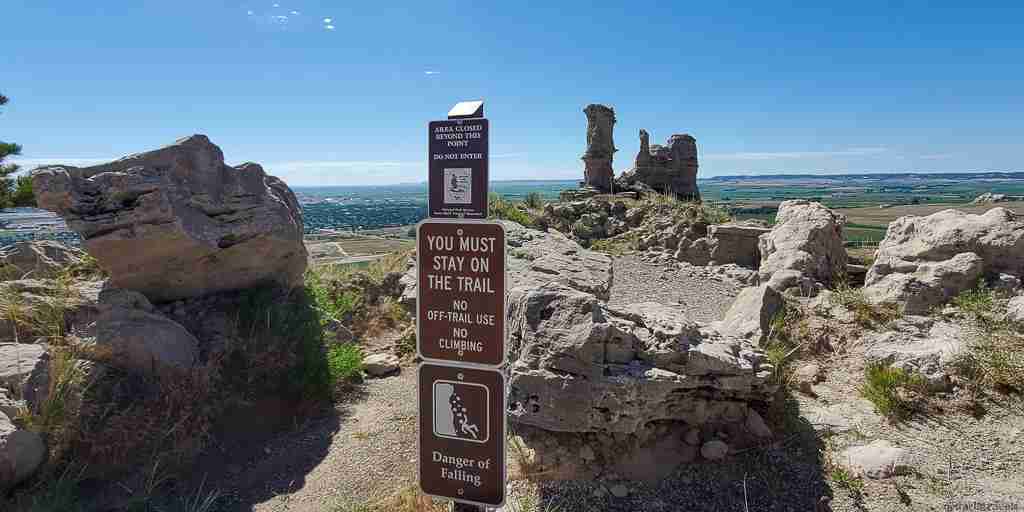
Caution: Signs at the Monument warn of the presence of rattlesnakes. Stay on the trails and stay alert.
The Daemonelix Trail
What’s a daemonelix? Sometimes called a “Devil’s Corkscrew,” a daemonelix is a type of fossil prevalent at Agate Fossil Beds. When discovered, the fossil’s origin was a mystery. Today we know a daemonelix is a burrow dug by a now-extinct beaver called the Paleocastor.
This one-mile (1.6 km) trail features several vertical daemonelix fossils exposed from eroded rock. Although the trailhead is close to the park entrance at Highway 29 and River Road, I recommend first heading to the visitor center about 2 miles (3.2 km) away to pick up a trail guide. The guide points out daemonelix fossils along the route, plus several additional points of interest, including lichens, ancient dunes, and soil geology.

And take a minute at the trailhead for the Daemonelix Trail to look for the cottonwood tree stand once part of James H. Cook’s Agate Springs ranch.
You can find an AllTrails map of the Daemonelix Trail here.
The Fossil Hills Trail
The second Agate Fossil Beds trail starts just outside the visitor center near two tipis. It ends at the top of Carnegie Hill, gaining about 250 feet (76 m) in elevation. On the way, the 2.8-mile (4.3-km) paved Fossil Hills Trail crosses over the Niobrara River and the wetlands area it maintains. Nebraska prairie spreads for miles in all directions on the climb, with occasional hills and ridges cropping up in the distance.

Rancher James H. Cook discovered fossils on Carnegie Hill in the 1880s. When formal excavations of the fossils commenced in the early 1900s, researchers found the remnants of a shallow watering hole 19 million years old. They surmised that massive numbers of prehistoric mammals died in and near the watering hole during a drought, creating a rich fossil site.

The Fossil Hills Trail used to contain some interpretive signs and displays relating to fossil finds. Unfortunately, most have been removed because of vandalism or damage from falling rocks, so it may take some imagination to envision the excavation sites. Still, this trail is worth it for the views and the proximity to one of the most fossil-rich bone beds of Miocene-era mammals.
You can find an AllTrails map of the Fossil Hills Trail here.
What about the “Bone Cabin”?

The park contains a third trail (1 mile, 1.6 km) branching from the Fossil Hills trail to the so-called “Bone Cabin.” Fossil researchers used this homestead cabin as a residence in the early 1900s, and it is restored to its 1910 appearance.
Unfortunately, this unpaved trail was somewhat overgrown, and I didn’t want to take a chance, given the possibility of rattlesnakes. However, if you’re skipping the trail, you can still see the Bone Cabin at a distance from the Fossil Hills Trail and the Visitor Center.
With trails that are neither too long nor too difficult, a day trip to the Agate Monument makes for a relaxing and educational excursion.
A closer and shorter hike is at another nearby historical site, Chimney Rock National Historic Site.
Chimney Rock National Historic Site
This cone-shaped rock formation with a protruding spire is visible for miles, thanks to Nebraska’s flat prairies. The Chimney Rock National Historic Site visitor center on County Road 75 in Bayard is about a 30-minute drive from Scottsbluff.
While a captivating bit of geology today, this landmark was a significant route marker for pioneers making their way west across the continent in the 1800s. Passing west of the Rock, the flat plains began to turn to more challenging, hilly terrain, ultimately approaching the Rocky Mountains.

Viewing Chimney Rock is free, but unlike other nearby national monuments, there is an admission fee ($8 at this writing) to enter the visitor center, which has a small museum and restrooms. Be careful walking around the exterior of the visitor center, as signs warn that rattlesnakes are out and about.
In addition, the Visitor Center has a large parking lot, an area with shaded benches on the front side, a small patio on the back side, and a covered wagon replica on the grounds.
The Chimney Rock Trailhead
To get to the trailhead for the Chimney Rock Trail (1 mile, 1.6 km), travel past the visitor center on County Road 75 to the T with County Road 98. Turn right on this dirt road that ends in a turnaround area. The trail terminates at a historical marker in front of the rock formation. Find an AllTrails map for this trail here.
The trailhead is a pleasant stop for a different perspective on the Rock. And even if you don’t hike the trail, take a turn around the small Chimney Rock cemetery-the entrance is opposite the trailhead. While some of the graves are recent, many markers are significantly older.

Caution: Trail reports indicate that the trail is narrow and best taken wearing long pants.
Caution: The trail reportedly has a high rattlesnake population.
After an excursion to Chimney Rock, head back to Scottsbluff for perhaps the best hiking near the city.
Scotts Bluff National Monument
The Scotts Bluff National Monument is just south of Scottsbluff in Gering, on the south side of the North Platte River. (Note that while Scottsbluff, the city, is one word, the National Monument is two words.) A 10-minute drive from downtown Scottsbluff will bring you to the visitor center parking lot. Admission to the Monument is free.
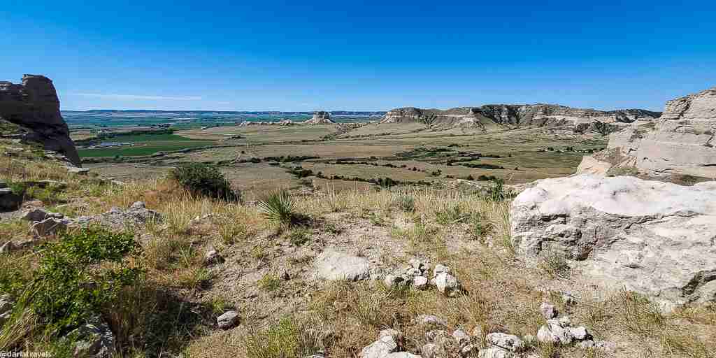
Two genuine bluffs (Scotts Bluff, South Bluff) and multiple rock outcroppings are surrounded by prairie, with the steeply sloping walls of the cliffs rising about 800 feet (244 meters) above the North Platte River. The gap between the bluffs, Mitchell Pass, was part of the Oregon and California Trails. Pioneers used this route to avoid the impassable badlands along the North Platte River starting in 1851. (Before that date, travelers had to take a much longer trek through Robidoux Pass further to the east.)

The Visitor Center has indoor and outdoor restrooms, a good-sized parking lot, and shaded picnic tables. Inside, view the extensive collection of (replica) watercolor paintings of William Henry Jackson. He spent time near Scotts Bluff observing activity on the Oregon Trail and featured his experiences in the artworks. Additionally, a 14-minute film explains the features of the Monument.
You can drive to the top of the bluff on a 1.6-mile (2.6-km) road, but why not walk up on the Saddle Rock Trail?
The Saddle Rock Trail
It takes only 1.6 miles (2.6 km) from the visitor center parking lot to the top of Scotts Bluff on the paved Saddle Rock Trail. Starting as a relatively flat path across the prairie grassland, it becomes much steeper at the bluff’s base. Then, following the cliff curve as it rises 435 feet (133 meters), the trail includes a hand-dug tunnel from one side of Saddle Rock to the other.
One notable feature of this trail is its mobile phone audio guide. Call the phone number provided at each guide marker and follow the prompts to listen to a few minutes of observations and explanations about that section of the trail.
Once at the top of the Saddle Rock Trail, it’s easy to move on to the short North Overlook trail (60 yards (55 meters) which continues gently uphill. It passes the bluff’s high point at an elevation of 4,659 feet (1,420 meters) above sea level.
From the North Overlook, make your way to the South Overlook on the trail of the same name. The South Overlook is approximately 300 yards (274 meters) past the summit parking lot.
Viewing the features of the North Platte River Valley from the overlooks, be sure to sight Chimney Rock far to the east. Also, note the badlands, the rough terrain along the North Platte River that obstructed pioneer wagons.
The Oregon Trail Pathway
Once you’ve returned from the top of the bluff, cross the visitor center parking lot to the short Oregon Trail Pathway next to replicas of covered wagons. The paved trail passes the wagons. When the pavement ends, keep walking through Mitchell Pass between Scotts Bluff and South Bluff on the exact route of Oregon Trail pioneers.
This 0.5-mile (0.8 km) trail also has a few markers explained via the mobile phone audio guide.

The end of the trail reverts to paved. It includes an interpretive sign recognizing William Henry Jackson, whose replica paintings can be seen in the visitor center. The trail’s end also provides a different perspective on Scotts Bluff and South Bluff across the pass.
The Prairie View Trail
One final trail at the monument site is the only trail open to bicycles. The Prairie View Trail is a 1.2-mile (1.9 km) paved trail between the visitor center and the park’s eastern edge. From the park boundary, the trail continues to the north as the Monument Valley Pathway, which I explained above. At this point, the trail also intersects with the City of Gering’s U-Street Pathway, which follows U Street for 2.5 miles (4.1 km) to the intersection with 10th Street.

Where to Eat and Drink in Scottsbluff, Nebraska
With all that driving and walking, you’ll need to grab something to eat in Scottsbluff. On my recent visit, I found that many businesses do not keep “big city” hours and that the hours of operation shown on the web were often incorrect. Therefore, I recommend calling ahead to avoid disappointment.
Here are my favorite places to eat and drink in Scottsbluff.
Try the Scooter’s Coffee drive-thru at Hwy 26 & Avenue B for a morning pick-me-up. This Nebraska-based coffee chain has been caffeinating customers quickly for over two decades. One morning, I enjoyed a smooth and mild decaf americano I picked up for the road.

Mexican restaurants abound in Scottsbluff, and Antonio’s Taco Shop (312 E Overland) serves up not only tacos but burritos, quesadillas, chimichangas, and tortas, with a variety of meat choices. Dishes at this casual, counter-serve spot arrive with a minimum of toppings, allowing you to customize to your liking at the salsa bar.
For a sit-down meal with an extensive menu of Mexican favorites, try Olé (1901 East 20th Street). Enjoy the colorful decor while sipping a top-shelf margarita or imported beer. Skip the complementary chips in favor of a grilled entree like Steak Ranchero or one of the many combination platters containing tacos, enchiladas, rellenos, tamales, and more.


Moving on to beer, the Flyover Brewing Company (1824 Broadway) serves excellent craft brews complemented by pizzas, salads, wings, and upscale starters. I was partial to the (NE)braska Pale Ale brewed with Citra and Mosaic hops and the slightly sweet Vienna Lager with a hoppy hint. The roasted brussels sprouts with prosciutto is a hearty appetizer. Follow it with Bomber Wings that come with a choice of seasonings: I’ll suggest the Memphis dry rub.
Backaracks Steakhouse and Grill (1402 E 20th St) is a steakhouse, burger joint, and sports bar all-in-one. You can also make a small wager playing keno here! Even on a crowded night, fast and friendly service complements the generous portions. I enjoyed a juicy avocado bacon burger. Salads, sandwiches, pasta, fish and chips, and several steaks were also on the menu. The fully stocked bar carries a good selection of craft beers on tap and Vamoose Vodka from Scottsbluff’s Great Plains Distillery, the only distillery in Scottsbluff.

Where to Stay in Scottsbluff, Nebraska
Most, but not all, Scottsbluff hotels appear along Highway 26 near the north of the city. You’ll find familiar brands from major chains and some independent properties. Many have pools and are pet friendly, but check for these amenities before booking.
- Budget Pick: Arcadia Hotel in Gering. Free wi-fi, sofa, microwave, refrigerator, no pool.
- Solid 3-star choice: Hampton Inn & Suites Scottsbluff. Complimentary breakfast, free wi-fi, indoor pool, hot tub, and guest laundry. Seven miles (11 km) from Scotts Bluff National Monument.
- Splurge: Hotel 21 & Co in Gering. Elegantly appointed, comfortable and spacious rooms, lobby bar, free wi-fi, view of Scotts Bluff National Monument, no pool.
Use this area map to choose your lodging near Scottsbluff:
Pin it for later!
Here’s a pin for your Pinterest boards. Pin it for later to remind yourself of walking opportunities in the Nebraska Panhandle. You can enjoy the city of Scottsbluff, Nebraska, and surrounding historical sites on short and easy to moderate hikes.

Have you been to Scottsbluff? Leave a comment below!
Went to college in Scootsbluff as nd enjoyed the city and the hiking trails, the Monument, fishing Lake Minatare, some pheasant hunting and the old fashioned feel of the town.
Thanks for your comment – I also like the old-fashioned feel of the town. I didn’t make it to Lake Minatare, but hopefully, I will on my next trip.
Why isn’t Hiram Scott mentioned here? I went to the Hiram Scott College 50 years ago!
Thanks for your comment. Hiram Scott and his tragic death are described in multiple sources and I wanted to focus on the trails here. It’s too bad Hiram Scott College wasn’t around longer.
I worked at the hospital there in 2015 as the interim CIO! I’ve drive through a couple of times since then.
Great post!
Thanks Stan!
We lived in Wildcat Hills while wife and I worked at Regional West Medical Center during 1980’s. Great community, outstanding people, our children visit annually during Oregon Trail Days.
Wayne
Thanks for your comment!. I’m glad to hear it’s a good community. I wanted to hike at the recreation area on my recent visit but ran out of time. It’s on my list for the next trip.