** Darla Travels is reader-supported.
When you buy through our links, we may earn a commission. **

Climbing the Rueter-Hess Incline in Parker, Colorado will get your heart pumping and your legs burning. This set of steps built into a steep hill isn’t in the mountains but requires effort similar to many hikes in the foothills. Keep reading to learn more about the Rueter-Hess Incline.
No time to Read? Pin it for later!
Here’s are three images for the Reuter-Hess Incline to add to your Pinterest Boards:


About the Rueter-Hess Incline
The Rueter-Hess Incline is a manufactured staircase included within the one-mile (1.6 km) Rosie Rueter Trail Loop near the Rueter-Hess Water Purification Facility in Parker, Colorado. Parker is about 26 miles (42 km) southeast of downtown Denver.
Sometimes called the Parker Incline or Rosie Rueter Incline, this relatively new trail opened for visitors in November 2020.
History of the Reservoir
It began in the 1980s when the Parker Water and Sanitation District (PWSD) anticipated water deficits due to the area’s rapidly expanding population. So, in addition to conservation, a plan for a dam and reservoir took shape.

Although not the first choice, the planners finally selected a site near Newlin Gulch for this project. After several years of preparation and construction, the Frank Jaeger Dam and the Rueter-Hess Reservoir started filling with water in 2012. It’s an “off stream” reservoir, meaning a river or other waterway does not supply it. Instead, a power plant pumps water into the artificial lake from nearby Cherry Creek. It is then released to a water treatment plant before moving to end-users.
I’ll put in some notes on the names here:
- Newlin Gulch is named for the farmer and rancher William Gilpin Newlin, who arrived in the area from Minnesota in 1865.
- Rosie (Rueter) Hess sold her land to the PWSD with the condition that the reservoir be named to reflect both her married and maiden names. Wife of Percy Hess, she ran a cattle ranch with her husband. A few vestiges of the homestead are still visible at the dam’s base.
- The 196-foot (59.7 m) tall dam is named for Frank Jaeger, a PWSD manager instrumental in the conception and execution of the reservoir project.
Several stakeholders established the Rueter-Hess Recreation Authority to plan outdoor activities based around the reservoir. The master plan includes 17 miles (27.4 km) of trails, including a 12-mile (19.3 km) loop around the lake. However, these trails, and the additional recreational facilities, won’t be complete for several years.
For now, the one-mile (1.6 km) loop draws runners, hikers, and casual walkers. Visitors can take the incline once or attempt it multiple times for more serious training. The trail is open from sunrise to sunset.
Climbing Rueter-Hess Incline
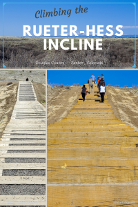
The Rueter-Hess Incline officially has 132 steps that gain 232 feet (71 m) elevation over about 0.1 mile (0.16 km). That’s an average of 17 inches (43 cm) per step, but all steps are not equal. Instead, they tend to be shallower at the bottom and steeper at the top.
Unofficially, the incline has 153 steps. This is important because step markers that gauge uphill progress reflect the unofficial number. Apparently, the lower steps, which are very far apart and not in a straight line, weren’t counted by the incline’s builders.

Getting Started
Just past the PWSD water purification plant in Parker, an unpaved parking lot serves as the trailhead. See the custom Trail Map below for details. From here, a natural surface path leads to a fork about 0.2 miles (0.3 km) into the hike. Take the track to the left, which curves around and climbs up for approximately 0.5 miles (0.8 km) before reaching the staircase.
Tips for the Climb Up
That short trail is a good warm up for the climb. The staircase, constructed of timber with natural surface treads, increases in grade most of the way up, except for one flattish section near the middle. The steps are broad and deep, with plenty of space to stop and stand if needed.
When planning the ascent, take the time of day and the season into account. The incline is in a line from southeast to northwest and has no shade at all. So the hill will get morning sun and continue to be sunny until much later in the day.

Following are some additional guidelines for the climb:
- Access to the staircase is via the loop trail. There is no way to bail out in the middle, other than turning around and taking the steps back down, so why not commit to getting to the top?
- No dogs or other pets are allowed on the stairs, but can be taken on the trails.
- The incline can be taken up or down, so be alert for anyone coming the opposite way.
- Every 25th step is numbered with unofficial numbering, resulting in 153 steps rather than 132.
- When moving uphill, it’s best to look ahead, especially if you suffer from balance issues or a fear of heights.
Keep moving uphill, and before you know it, you’ll be standing at step 132 (or 153 if you follow the numbering on the staircase).

The Peak and Descent
At the top of the staircase, there are plenty of things to see. The reservoir is visible on the other side of Hess Road, and on a clear day, look for the majestic Pike’s Peak toward the south. To the east, note the water purification plant and the town of Parker. Behind the hill, there’s not much to see in the foreground, but one day the Recreation Authority will build new trails here. Finally, the Rocky Mountains are prominent to the far west.

Once you’re ready to move on, the rest of this loop trail moves downhill back to the fork. It is also possible to return to the start by descending the stairs.
The trail is short enough to be a multi-loop workout, with the total distance and number of climbs up to the individual.
Trail connections
As noted above, the Recreation Authority has plans to build many more trails around the reservoir. The Phase II trails in place start with the Newlin’s Gold Trail that takes a sharp left at the top of the incline. Newlin’s Gold crosses Hess Road and connects to the Coyote Run Loop, a 4+ miles “intermediate” trail.

Finally, the rather dull Arapahoe Canal Trail (1/3 mile, 0.5 km) connects the trailhead to the East-West Regional Trail. The East-West Regional Trail is a 28-mile (45 km) route, mostly natural surface, between Parker and Highlands Ranch. Read more about the East-West Regional Trail here.
Rueter-Hess Incline compared to nearby Inclines
The Rueter-Hess Incline is similar to the Castle Rock Incline, also known as Challenge Hill in nearby Castle Rock, Colorado (Philip S. Miller Park). The length and elevation gain of the two inclines is similar, but the Rueter-Hess Incline has only 132 steps (official count; 153 steps unofficially) compared to the 200 stairs on Challenge Hill. For a guide to Challenge Hill, click here.

Both Rueter-Hess and Challenge Hill are significantly shorter than the Manitou Incline in Manitou Springs, Colorado. The Manitou Incline came about when hikers started climbing up old railroad ties that formerly carried a cable car for transporting building materials. This famous but grueling climb is 2,744 steps that move forward less than a mile (1.6 km) while climbing over 2000 feet (609 m). That makes the average grade about the same as the shorter inclines but over a longer distance and ten times the elevation.
Post-Hike Breakfast in Parker
After conquering the Rueter-Hess Incline, you’ll be ready for a meal. Stop by Doug’s Diner in Parker (18595 E Mainstreet #140) for a late breakfast or lunch. This local chain is known for its fresh, homemade ingredients. They offer classic omelets, southwestern favorites, pancakes, waffles, and more for breakfast, while lunch lends itself to their savory burgers and sandwiches.
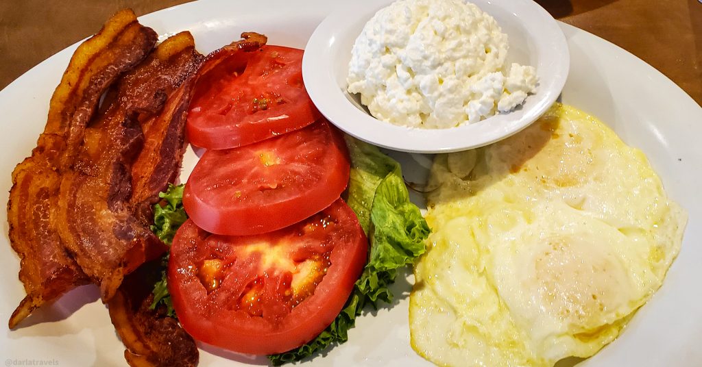
Doug’s Diner in Parker is located in the Parker Hotel.
Where to Stay Near the Rueter-Hess Incline
Speaking of hotels, do you have a place to stay in Parker? Use the map below to find and book your vacation rental or hotel in Parker:
Custom Map of the Rueter-Hess Incline Climb
I created this map on AllTrails to highlight information about Rueter-Hess Incline.
Legend: Red: Rueter-Hess Trail; Blue: Incline Challenge; Yellow: Arapahoe Canal Trail
Don’t see the map or want to see the original? Click here to go to the map pages on AllTrails.
Other Trail Information
| Getting There | 11865 Heirloom Pkwy Parker CO 80134 Turn west from Heirloom Parkway at the sign for the Rueter-Hess Water Purification Facility; continue west to the parking area. |
| Distance | 1 mile (1.7 km) for the entire loop |
| Difficulty | Moderate to hard |
| Trail Type | Loop |
| Trail Surface | Natural, with timber steps |
| Besides Hiking: | Trail running |
| Links | Rueter-Hess Recreation Authority Page Colorado Trail Explorer (COTREX) Page AllTrails page for Rueter-Hess Incline |
| Closest Towns | Parker |
Wrapping Up the Rueter-Hess Incline Climb
The Rueter-Hess Incline in Parker, Colorado, provides an opportunity for uphill climbs without visiting the mountains. Finish the 132/153-step staircase once or multiple times for a more intense workout.
Note: This post was originally published on April 6, 2022 and updated on September 26, 2022 and October 25, 2024.
Would you climb Rueter-Hess Incline? Leave a comment below!
Good information
Helpful. Thanks!
Glad you enjoyed it!
Wow- the views were worth the steps, and I’d say you earned that breakfast at Doug’s Diner.
Glad to know I’m not the only one that thinks so!
We’ve done the Manitou Incline and the mini incline in Castle Rock, but haven’t tried the one in Parker yet. Looks like it’s a great way to train for the longer Manitou climb.
I think you’re right about using this (or the Castle Rock incline) as training for Manitou. I need to get down to Manitou and give that a try!
Well, I cannot even imagine how it is to do the Manitou Incline. 2,744 steps!!
Will wait for you to test them out, and show some pics 😉
Thanks for the encouragement, Ivan. Maybe I’ll get up there next year.
We’ve done the Castle Rock Challenge Hill many times. Of course, my daughter raced up the steps no trouble. So I had to pretend it didn’t trouble me either, and cover my heavy panting/breathing at the top. Will have to try to Rueter Hess Incline sometime.
Lance, why am I not surprised?! I hope you can get to the Rueter-Hess incline and try it out. To me, it feels a little easier to do than Castle Rock!
Another beautiful hiking adventure-there are SO many in Colorado. Definitely think it’s one of the top states for hiking. I also love the All Trails embed. Didn’t know that was possible!
Thank you Heather! Glad you enjoyed the post!
What a challenging adventure! Thanks for introducing the Rueter Hess incline climbing. The hike of 153 steps sounds perfect for seasoned hikers who want to train to get more fit. It is also great that there is a place to get a good breakfast after the climb. Doug’s Diner breakfast image looks inviting! The views from the top will be the reward at the end. Awesome!
Thank you for the comment-glad you enjoyed the post!
A very accurate and detailed overview of the Parker Incline. It was a pleasure to read and so happy to have found someone that enjoys these trails.
They have recently opened up more trailed and are able to see the reservoir.
Thanks for your comment! I need to get out there sometime and see all the new stuff!