** Darla Travels is reader-supported.
When you buy through our links, we may earn a commission. **

Are you ready for a suburban winter hike that doesn’t require a lot of preparation? Look no further than Highlands Ranch, Colorado. When temperatures drop, snow falls, and ice forms on trails, hiking might not seem very appealing. But with some preparation, a winter hike in Highlands Ranch can be a safe and rewarding experience. So whether you’re looking for a leisurely stroll or an intense workout, keep reading to learn why a suburban hike in Highlands Ranch should be on your winter agenda.
Why pick Highlands Ranch for a Winter Hike?
Highlands Ranch is a Colorado community with over 100,000 residents on the south edge of the Denver Metro area. This Douglas County development is known for its ultra-strict homeowner’s association, repetitive architecture, and high cost of living. If these attributes make you want to run for the hills, stay with me for one minute. This suburban stronghold’s redeeming feature is the extensive trail system that winds around and through all the cookie-cutter homes. My opinion? Winter is the best time to hike these trails.
What Makes Highlands Ranch a Perfect Place for Winter Hiking?
- The first reason to consider Highlands Ranch for winter hiking is its sheer size. The community covers over 22,000 acres (89 square kilometers), but not all houses. In fact, 61% percent of the land is devoted to open space or recreational purposes, including 70 miles (112 km) of paved and natural surface trails.

- Second, the Highlands Ranch Metro District plows snow on 150 miles (241 km) of trails and sidewalks. That’s right, snow will be removed from the paved trails. Plowing starts after an accumulation of three inches of snow or if snow is considered likely to remain on the ground for 24 hours.
- The landscape is the fourth feature that makes winter hiking pleasant in Highlands Ranch. The area has enough rolling hills to keep things interesting, even if it’s flat compared to the nearby foothills. Most hikes are around 3-5% grade on average, with occasional spots slightly steeper. Even on longer, steeper hikes, the route’s high point will likely be, at most, about 400 ft (122 m) higher (or lower) than the starting point.
- Fifth, many trails wend through open spaces with very few trees. While the lack of shade can be downright brutal in the summer, a sunny winter day can make for quite a comfortable walk.
- Sixth, the trails pass by oodles of neighborhood parks. Many of these parks have open restroom facilities even in the winter.
- Finally, while over 100,000 people live in Highlands Ranch, you’ll see shockingly few of them on the trails in the winter. Despite the high population, you won’t find crowds on colder days.
How to Prepare for a Highlands Ranch Winter Hike
Many things make Highlands Ranch great for winter hiking, but there are a few things to know to help you maximize your safety and enjoyment.

- First, while the paved trails are plowed, snowmelt can refreeze and stick around in shady spots. So it’s a good idea to bring a traction device such as Yaktrax or microspikes, whether for icy patches that crop up on the pavement or cover soft surface trails.
- Second, many routes will include a combination of paved and soft-surface trails and a bit of sidewalk. If you intend to use a soft-surface path, be ready for the possibility of snow, ice, or mud. Again, bring a traction device and have a plan to detour or backtrack if needed.
- Next, Highlands Ranch is big, but it’s a planned development, not a city. This means some amenities won’t be available if you’re not a resident or don’t work there. For instance, you won’t be able to get into one of the four recreation centers to use the restroom (or anything else).
- Additionally, some trails are private, for residents only. These trails are generally south of the housing. They are reasonably well-marked, so it should be simple to avoid them.
- Finally, although the trail system is extensive, getting around on the trails can be challenging because car travel is prioritized over outdoor activity. Some trails dead-end at busy streets. Others will continue on the opposite side of the road but with no safe way to cross over. Or a trail might end and require a few blocks of walking on sidewalks in a neighborhood to get to another path.
You’re ready for a suburban hike if you’re aware of these quirks and possible hiccups on the Highlands Ranch trail system!
Nine Must-Visit Trail Routes for the Best Highlands Ranch Winter Hike Experience
So what are the best hiking routes in Highlands Ranch? They all start at locations with ample parking and restrooms, either at the parking site or somewhere along the trail. The suggestions include regional parks with many amenities, historic sites, and views of the Rocky Mountain Front Range. Here are nine of my favorites, along with detailed trail maps and written directions. In some cases, the route information may seem complicated, but it should make sense if used in connection with the trail map. All distances and elevations are approximate.
Note: It is imperative to follow all traffic laws and exercise caution on these suburban hikes!!
1. A Loop Hike from Redstone Park
This suburban hike starts at Redstone Park (3280 Redstone Park Cir.), heads into the heart of Highlands Ranch, and loops around before returning to the start. Highlights include Kistler Park and good views of the Rocky Mountains.

Total Distance: 8 miles (12.9 km)
Starting Elevation: 5587 ft (1703 m)
Highest Elevation: 5863 ft (1787 m)
Route Information-Loop Hike from Redstone Park
From Redstone Park, head east on the Marcy Gulch Trail. The trail sequence is:
- Marcy Gulch,
- Foothills,
- Diamond K,
- Kistler,
- Grand View,
- the sidewalk on Broadway,
- the sidewalk on W. Winterthur Way, and
- Marcy Gulch Trail back to the start.
Note: This hike includes three unmarked street crossings that are UNSAFE, marked on the map below. Take the sidewalk to the nearest crosswalk to continue the route safely.
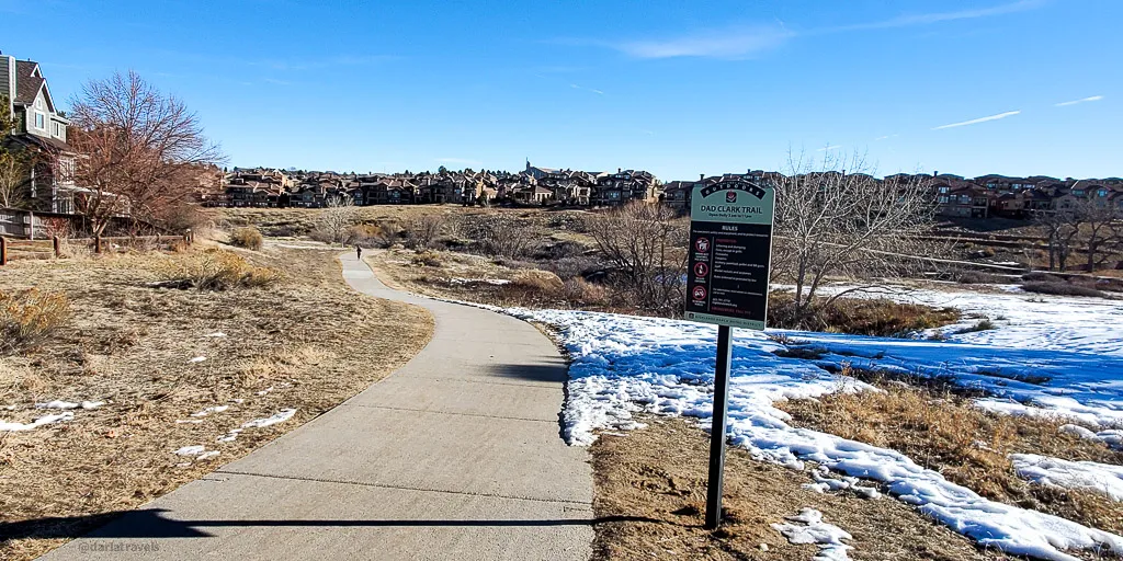
2. A Loop Hike from Dad Clark Park
A Loop Hike from Dad Clark Park
This loop from Dad Clark Park (3385 Astorbrook Circle) is a proper suburban hike that includes paved trails, natural surface trails, sidewalks, and some road crossings. It passes through open spaces, neighborhood parks, and suburbia’s front and back yards. Highlights include:
- A view (from the Diamond K Trail) of the former “Highland Ranch,” which supported dryland farming, dairy, and Angus cattle, sheep, hogs, and chickens starting in 1861; and
- A windmill marking the spot of the main water well formerly used for the ranching headquarters and mansion.

Total Distance: 7 miles (11.3 km)
Starting Elevation: 5587 ft (1703 m)
Highest Elevation: 5863 ft (1787 m)
Route Information-Loop Hike from Dad Clark Park
From Dad Clark Park, walk through the park to the Grand View Trail. The trail sequence is:
- Grand View,
- Middle Fork,
- the sidewalk on S. Venneford Ranch Road,
- Diamond K,
- the sidewalk on Burntwood Way,
- Kistler,
- Grand View,
- Gateway Drive,
- unnamed soft surface trail,
- Mountain View (sometimes marked as Marcy Gulch),
- Dad Clark,
- the sidewalk in Red Tail Park,
- Firelight,
- the sidewalk along Ashworth Avenue,
- East Fork,
- the sidewalk on Summit View Pkwy.,
- the sidewalk on Astorbrook Way, then Astorbrook Circle, ending at the starting point in Dad Clark Park.
- Note: This hike includes an UNSAFE street crossing, marked on the map below. Take the sidewalk to the nearest crosswalk to continue the route safely. Several others require caution using crosswalks.
3. An Out-and-Back Hike from Highland Heritage Park on the West Big Dry Creek Trail
Compared to the loops above, this out-and-back route is easy to navigate. Start at Highland Heritage Regional Park (9651 S Quebec St.), a large recreation area with many amenities, including a spacious parking lot. This route takes the West Big Dry Creek Trail to its end, then adds on a short climb at the East/West Regional Trail to Highlands Point, a stunning overlook with an enormous compass on the ground pointing to prominent landmarks in all directions.

Total Distance: 7.7 miles (12.4 km)
Starting Elevation: 5860 ft (1787 m)
Highest Elevation: 6263 ft (1909 m)
Route Information-West Big Dry Creek Trail to Highlands Point
From Highland Heritage Park, head west on the sidewalk to the West Big Dry Creek Trail and follow it south. This paved trail turns to a soft surface path at Grigs Road, eventually intersecting with the East/West Regional Trail. At this point, it’s less than 1/8 of a mile (250 m) uphill to reach the Highlands Point overlook.
4. The Dad Clark Trail from Northridge Park
Starting at Northridge Park, take the Dad Clark Trail through a peaceful open space rich with birds and riparian areas, passing through Sand Creek and Toepfer Parks.
Total Distance: 5.8 miles (9.4 km)
Starting Elevation: 5581 ft (1701 m)
Highest Elevation: 5827 ft (1776 m)
Route Information – Dad Clark Trail from Northridge Park
Park at Northridge Recreation Center (8800 S Broadway), adjacent to Northridge Park. Follow the trail (either direction) from the edge of the far parking lot and stay on the paved Dad Clark Trail. Just past Toepfer Park, the trail forks, and each branch dead ends in a neighborhood. This route takes the shorter path but includes a walk around Toepfer Park. The map below shows the two ways to get on the trail from Northridge Park.
5. A Hike Through Cheese Ranch and Welte Parks
This hike starts at Highland Heritage Park (9651 S Quebec St.), moves through Cheese Ranch Historic Park, then takes a turn through the narrow Welte Park before reversing course back to the start. Cheese Ranch Historic Park features a fishing pond, a charming historic windmill, and a community garden, likely dormant in the winter. Be sure to stop and take in the mountain view at the intersection with the Vista Trail.

Total Distance: 6.2 miles (7.8 km)
Starting Elevation: 5860 ft (1787 m)
Highest Elevation: 5860 ft (1787 m)
Lowest Elevation: 5761 ft (1756 m)
Route Information-Cheese Ranch and Welte Parks
From Highland Heritage Park, take the pavement roughly north, past the amphitheater toward S. University Blvd. From here the trail sequence is:
- the sidewalk on S. University Blvd,
- the sidewalk on Quebec Street,
- the sidewalk on Silver Spur Lane,
- Cheese Ranch Trail (also marked as “Big Dry Creek Trail at Settler’s Village”),
- Welte Park.
Note: This first part of this hike includes walking across and along busy streets. Use crosswalks for safety.
6. Hiking the East Fork and Wildcat Natural Areas
Highland Heritage Park (9651 S Quebec St.) is again the starting point for another out-and-back hike in the open space of Highlands Ranch.
The East Fork Natural Area is a wide gully between two neighborhoods with the paved East Big Dry Creek Trail running through it. The Wildcat Trail followers the Wildcat Natural Area, a narrow strip of land that abuts the border between Highlands Ranch and the city of Lone Tree. (Lone Tree hikes include the Willow Creek Trail and Bluffs Regional Park). The Wildcat Trail is a wide soft surface trail that follows a line of transmission towers. The two tracks are connected by the paved Vista Trail.
This hike features excellent views and a mostly flat route–only 98 feet (30 m) of elevation change over the entire Distance.

Total Distance: 5 miles (8 km)
Starting Elevation: ft (1787 m)
Highest Elevation: ft (1787 m)
Lowest Elevation: ft (1756 m)
Route Information-East Fork and Wildcat Natural Areas
Start in Highland Heritage Park and take the paved East Big Dry Creek Trail toward Quebec Street–the trail will pass under Quebec.
The trail sequence is:
- East Big Dry Creek,
- Grand View, and
- Wildcat, with the turnaround point in Altair Park just short of Quebec Street.
Note: This hike includes an unmarked, UNSAFE street crossing, noted on the map below. Take the sidewalk to the nearest crosswalk to continue the route safely.
7. Walk the Spring Gulch Trail from Redstone Park
From Redstone Park (3280 Redstone Park Cir.), the paved Spring Gulch Trail can be an easy out-and-back route, but if conditions allow, why not turn it into a loop hike with the Douglas County East/West Regional Trail? While the paved Spring Gulch trail passes through a beautiful natural area, the dirt East/West trail section allows for fantastic views of the front range.

Total Distance: miles (11.4 km)
Starting Elevation: 5587 ft (1703 m)
Highest Elevation: 5797 ft (1767 m)
Route Information-Spring Gulch Trail from Redstone Park
Start at Redstone Park and take the Spring Gulch Trail. After a short distance, the trail intersects the Douglas County East/West Trail. Take the East/West Trail past the Spring Gulch Equestrian Center and around to the back side of the houses. At the intersection with the Spring Gulch Trail, return to the start at Redstone Park on Spring Gulch. Spring Gulch is not precisely in a straight line. There are multiple intersections where the trail isn’t directly on the other side of a street, and a slight zig-zag is required.
Note: This hike includes an unmarked street crossing that is UNSAFE, marked on the map below. Take the sidewalk to the nearest crosswalk to continue the route safely.
8. The Foothills Trail from Northridge Park
The Foothills Trail is a diagonal route cutting across Highlands Ranch. It’s accessible from Northridge Park via the paved Dad Clark Trail. The Foothills Trail is mostly a dirt surface but does have some paved sections. It crosses three significant thoroughfares as it traverses Douglas County’s rolling hills. Its fantastic views and lots of ups and downs make this route notable.

Total Distance: 8 miles (12.8 km)
Starting Elevation: 5594 ft (1706 m)
Highest Elevation: 5784 ft (1760 m)
Route Information-Foothills Trail from Northridge Park
There are only two trails on this route, the Dad Clark Trail and the Foothills Trail. Park at Northridge Recreation Center (8800 S Broadway) adjacent to Northridge Park. Follow the paved trail (either direction) and stay on the paved Dad Clark Trail. At the intersection with the Foothills Trail, turn south. The map below shows one path from Northridge and a return to it on the other.
Note: This hike includes UNSAFE street crossings, marked on the map below. Take the sidewalk to the nearest crosswalks to continue the route safely.
9. High Line Canal Trail From Fly’n B Park
This hike is undoubtedly “last but not least.” The High Line Canal Trail is a famous regional trail that covers 71 miles (114 km) across the Denver metropolitan area. Allegedly one of the longest “continuous urban trails” in the United States, this epic trail passes through Highlands Ranch. This trail segment starts at Fly’n B Park (2910 Plaza Dr.) and follows the cottonwood-lined canal through the Highlands Ranch Golf Club and, further along, to the Spring Gulch Pond.
At the start of this hike, be sure to stop and see the Fly’n B House (originally the Matthew Plews House), which was built in 1906. The restroom building is behind it.

Fishing is allowed at both Johnny’s Pond in Fly’n B Park and Spring Gulch Pond (Age 16+ must have a Colorado state fishing license)
Total Distance: 6.2 miles (10 km)
Starting Elevation: 5597 ft (1706 m)
Highest Elevation: 5774 ft (1760 m)
Route Information- High Line Canal Trail from Fly’n B Park
Starting at Fly’n B Park (formerly part of the Fly’n B Ranch), take the trail south through the Wind Crest Senior Living Community, followed by the Highlands Ranch Golf Club. Past Santa Fe Drive, then a somewhat industrial area, crossing Carder Court before arriving at Spring Gulch Pond.
Note: to get across Sante Fe Drive, it was formerly necessary to walk in the slightly creepy canal culvert underneath the road. The High Line Canal Conservancy is currently improving the trail with a pedestrian underpass here, to be completed in 2024. Therefore, a detour is in place. Follow the signs, as the detour is not included in the map below.
Note: This hike includes UNSAFE street crossings, marked on the map below. Take the sidewalk to the nearest crosswalks to continue the route safely.
Where to Stay in Highlands Ranch, Colorado
The variety of hotels around Highlands Ranch ensures that visitors can find comfortable and convenient lodging to suit their preferences, whether they’re seeking a relaxing retreat or a convenient base for exploring the area. Explore lodging near Highlands Ranch using this map:
Wrapping Up Winter Hikes in Highlands Ranch
Winter can be a great time to explore the great outdoors, and Highlands Ranch has some of the best trails for a suburban winter hike experience. From Redstone Park to Highland Heritage Regional Park, combine the routes with a few sidewalk connections to get your winter hike on. You’ll visit natural areas with stunning views and have a chance to explore historic sites on former ranch land. So whether you’re looking for a scenic, peaceful, or challenging winter hike, Highlands Ranch provides plenty of options.
Pin it for Later!
Here are two pins for your Pinterest Boards:
Where was your last suburban hike? Leave a comment below!
Updated 12/18/2023
Hi Darla; thank you for sharing the 9 hikes in Highlands area. I WILL be checking those out. I was surprised & a little disappointed going to Washington Park in Denver this morning with slippery ice/snow on the tails. In all fairness, they were working on getting the trails cleaned up. But @ 77, I MUST be very careful. To add in a little extra mileage, I went north on Marion St. and did slip on some black ice but my walking stick kept me from falling.! Greg 17 Feb. 2023
Thanks Greg! Please do be careful out there, especially this time of the year. Get yaktrax or something similar for better traction on icy areas.
Hi Darla; getting an error message on your 2nd suggestion from Dad Clark Park: “404
We’ve reached the end of the trail
The page you’re looking for either doesn’t exist or has a new link. Let’s get you back on the right path.” https://www.alltrails.com/explore/recording/activity-6344518105-7f975a5
Thank you for all you do, Greg 17 Feb. 2023
Thanks for bringing this to my attention. Please clear your history and try again – I think I have worked out all of the gremlins.
Hi Darla;
Covering 2 items here.
1st, I am now able to get into your suggested walk #2 map @ https://www.alltrails.com/explore/recording/activity-6344518105-7f975a5?u=i thank you.
2nd, I finished your suggested loop #1 yesterday or @ least about 97% of it. Diamond K trail closed near Broadway @ the west end. Pics on request. They did NOT post any completion date @ the location.
IF you or anyone still wants to do your loop, they can substitute Diamond K trail with Front Range trail “IF” they don’t mind getting into a LOT of MUD @ least for now.!
Thanks for all you do, Greg 26 Feb. 2023
Greg, thank you for your informative comment. The trail closure must be pretty recent, but at least there is a workaround. Unfortunately, it is getting to be mud season. I try to go out early so that I only encounter frozen mud!
Hi, I recently moved to this area from SW Colorado and am so glad to have found your website describing area hikes. Thank you for putting this info out there!
Hi Pat, You’re very welcome and thank you for your comment. I’m so glad you found the site to be useful!
Hi Darla. There are so many intersting and picturesque hikes in Highland Ranch. We would love to see the windmill in Cheese Ranck Historic Park, to enjoy the veiws of the foothills and snow covered mountain peaks of the Rockies, to stroll along the tree lined canal and to see Fly’n B house, and much more. Thank you for sharing your favorite hikes and beautipul pictures.
Thanks for stopping by, Natalia!
Great article. Love to get some background like this before hitting the trail. Thanks.
Thanks for your comment, Alan!
This looks like a gorgeous hike — even in the cold and dreary winter weather. I love all of the detail you share in your hiking posts!
Thank you Sage, I’m glad you enjoyed it!
Hi Darla; I finished your 9 Highlands Range trails today. Thankyou for sharing, Greg 28 Mar. 2023
That’s great, Greg! I hope you enjoyed them. Let me know if there is any trail you are interested in that I didn’t cover.
Darla, thank you for sharing all these hiking trails in Highland Ranch. There is nothing like taking a hike on a crispy sunny winter morning or afternoon in Colorado. The views on the trails are spectacular, especially the ones going west, facing the Rocky Mountains. A Loop hike from Dad Clark Park, Spring Gulch Trail, the Foothills trail, and High Line Canal trail would be my favorites. Photos of all the hikes are wonderful.
Thank you Natalia, I hope you are getting out for some hiking this winter!
Winter hikes with trails cleaned of snow? Sign me up!
While the authorities do care to make trails accessible throughout the year, it’s a shame they do not go all the way – arranging street crossings, for example.
However, it’s great to have available resources such as your page, and judging by the comments under the article, you have engaged hikers among the readers, which is the greatest compliment for any writer. Keep up with nourishing that community, and good luck!
Thanks for the encouragement, Ivan. I will keep it up!
Highlands Ranch looks like a great place to try out my new pair of Sketchers1
Highlands Ranch is the perfect spot! Take it easy and watch your step while you’re out there enjoying the scenery!