** Darla Travels is reader-supported.
When you buy through our links, we may earn a commission. **

The North Table Mountain Park trails go around a flat-topped mountain, up its steep sides, and wind through open grasslands on the mesa in Golden, Colorado. Surrounded by the city, it’s easy to get to, yet the summit feels remote. Jefferson County Open Space manages the sensitive natural resources here while supporting enough trails for multi-hour hiking.
Keep reading to learn how to take advantage of North Table Mountain Park trails.
About North Table Mountain Park
North Table Mountain Park is just one of 28 parks managed by Jefferson County Open Space (JCOS).
This mountain park covers 1,998 acres (808.5 hectares, including 17.3 miles (27.8 km) of trails that meander up, around, and on top of this mesa summit. North Table Mountain is a classic mesa: a flat top with sides that rise steeply from plains below. It’s approximately two miles long by one mile wide (3.2 x1.6 km), and its flat top is only about half as many acres as the base.
How did this mesa arise at the junction of the Rocky Mountains and the Great Plains?
Around 62 to 64 million years ago, a lake of lava from a nearby volcanic vent flowed over the existing sedimentary rock layers for about ten miles (16.1 km). Over time, three lava flows cooled on the surface, forming hard basalt. Rivers began eroding the softer sedimentary rock underneath. But North Table Mountain resisted this deterioration to some degree due to its protective basalt cap. North Table Mountain and its sister peak, South Table Mountain, are separated by Clear Creek. Once, this waterway was powerful enough to cut a channel through the rock layers to create the two separate mesas. South Table Mountain is also a JCOS Park with hiking trails.

As far as human activity goes, there is a record of homesteading on North Table Mountain as early as 1894. In addition, several owners ranched on the mountain for many years. Mining and stone quarrying also happened for short periods.
North Table Mountain became a park through land swaps and bond funding from 2002-2009. Today, all trails in the park are available to hikers, mountain bikers, and equestrians, except the short Lichen Peak trail, which is hiker-only. The park also contains several spots for rock climbing.
As mentioned above, there are enough trails in North Table Mountain Park to walk for several hours. So get started with the route descriptions in the next section.
The North Table Mountain Park Trails
I’ll start at the West Trailhead, with a large paved parking lot, excellent restroom facilities, and water. The West Trailhead is accessible from Highway 93 in Golden, Colorado. From here, get on the North Table Loop Trail. The entire loop is 7.4 miles (11.9 km) with easy to black-diamond-difficult terrain depending on the trail segment.
North Table Loop Trail
From the trailhead, the choices are:
1) head north (left) for an easy trail segment or
2) hike straight to the top of the mesa on a steep incline.
If choosing “option one” to complete the entire loop, be aware that the easy trail gets more challenging on the north and east sides of the mountain, where there are climbs on the steep sides of the mesa. The uphill continues up on the east side, followed by a downhill stretch in Cottonwood Canyon before climbing up again around the peak’s south side. Finally, the trail reaches the top of that steep incline above the West Trailhead, and the loop completes by descending the steep slope back down to the trailhead and parking lot.
Of course, choosing “option two” and doing the steep uphill climb first means that the rest of the loop is mostly downhill except for a climb up on the east side.
How steep is that first climb, really? My GPS recorded an elevation gain of 439 feet (134 m) on this 0.5 mile (0.82 km) hill, an average 17% grade. It’s not easy, and I have seen more than a few people stopping to catch their breath on the ascent. On the other hand, I’m not a particularly fast hiker, and I can get to the top in about 13-14 minutes. So while effortful, the tradeoff is that it doesn’t take too long.
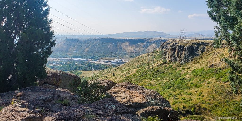
At the top of the mesa, take a minute to recover and observe the “Sea Cliffs” rock walls to the south.

The steep “option two” route also connects to additional trails on top of the mesa. Some of these trail descriptions are below.
Tilting Mesa Trail
The first intersecting trail from the “Option 2” uphill North Table Loop Trail is the Tilting Mesa Trail, just after the terrain flattens out. Tilting Mesa is a 0.9 mile (1.4 km) trail that’s mostly flat. Taking this trail to the middle of the mesa reveals far-reaching grassland views without seeing the ground below. The mesa is so large that there’s no reference point to signal the elevation several hundred feet above the mountain’s base.
Much of the flat top is like this, making it an excellent escape from the city below without traveling far from metro Denver.
The Tilting Mesa Trail terminates at an intersection with the Mesa Top Trail, described later below. Before I get to that, I’ll discuss the Lichen Peak trail.
A Note on Lichen

The Tilting Mesa and Lichen Peak trails cut through grassland as well as areas with less vegetation and high levels of lichen. What’s a lichen? Lichens are a double organism: a fungus combined with microalgae or cyanobacteria. The algal cells are capable of photosynthesis, a source of energy. The fungi use this energy, and in return, they supply a protective environment for the algae to grow. For example, the fungi can produce pigments that shield the algae from the sun’s harmful ultraviolet radiation. On North Table Mountain, large amounts of lichen cover exposed volcanic rock. In lichen-heavy areas, there are relatively fewer plants and soils. But lichens assist in creating soil by secreting acidic chemicals that break down the rock they cover.
Lichen Peak Trail
The Lichen Peak Trail is a short (0.2 mile, 0.3 km) trail branching from the Tilting Mesa trail just past its intersection with the North Loop Trail. Lichen Peak is the highest point on North Table Mountain at an official elevation of 6,552 feet (1,997 m). The additional height to summit Lichen Peak is only about 85 feet (26 m) from the Mesa Top Trail.
There are at least three reasons to complete this short, hiker-only trail:
- Bragging rights for hiking to the top of a mountain.
- Observing tons of lichen-covered rocks along the path and at the summit.
- Views of the Denver metro area and other front-range peaks, including Longs Peak and Pikes Peak.

Mesa Top Trail
The Mesa Top Trail name is a little misleading. While it does traverse the flat top of North Table Mountain, it also descends to meet the North Table Loop Trail on both the north and east sides of the mesa. The Mesa Top trail continues the trek through grassland landscapes. Near its intersection with the Tilting Mesa Trail, the Mesa Top Trail passes by a lake-if my research is correct, it’s the largest natural body of water on the mountain when full.

The Mesa Top Trail intersects with one additional trail on North Table Mountain, the Rim Rock Trail, described below.
Rim Rock Trail
The Rim Rock Trail is a 1.7 mile (2.7 km) trail that forms a loop with the Mesa Top Trail. It’s closed for part of the year (the only trail in the park with a closure). That’s because this part of the park is a refuge for migratory grassland bird species. These birds nest at ground level and include the horned lark, vesper sparrow, western meadowlark, and grasshopper sparrow. If the birds are around during your hike, you will undoubtedly hear them singing, even if they are hard to see.
I’ve seen reports that the reason for the trail closure is to protect nesting raptors. However, while raptors fly over and ride the thermals near the edge of the mesa, I doubt this is a nesting area for such birds, as it is devoid of trees.

The trail is closed from February through July to safeguard the grassland birds. At last check, the fine for using the trail during the closure was $150.
After completing the Rim Rock Trail, you’ll be back on the Mesa Top Trail. From there, go downhill to meet the North Table Loop, or toward the middle of the mesa to the intersection with the Cottonwood Canyon Trail.
Cottonwood Canyon Trail
The Cottonwood Canyon Trail (1 mile, 1.6 km) connects the Mesa Top Trail to the North Table Mountain Loop. This moderate trail heads down a canyon carving out the mountain’s southeast side. This canyon allows good views of the cliffs on either side of it.
Golden Cliffs Trail
The Golden Cliffs Trail is a 0.8 mile (1.3 km) trail branching from the North Table Loop on the southwest side of the mesa. The Golden Cliffs trail forms a loop with the Climbing Access Trail (0.4 miles, 0.6 km), which leads to a popular rock climbing area.
Park at the Golden Cliffs trailhead (restrooms available) on Peery Parkway and climb up a 0.3 mile (0.5 km) trail to access these trails directly. See the custom map below for details.
The previous owner of the Golden Cliffs area is the Access Fund. This organization donated the property to JCOS in 2014 with the stipulation that the climbing area remain accessible. For more information on rock climbing near the Golden Cliffs trailhead, see the Golden Cliffs page on the Mountain Project.
Other Trails on North Table Mountain
The park contains a few other trails and trail access via surrounding neighborhoods. These features are shown on the custom map below.
Hiking in North Table Mountain Park
With over 17 miles (27 km) of trails, a North Table Mountain hike could take several forms. The AllTrails page for North Table Mountain Park shows several trails combinations with round trip distances ranging from 3.1-15 miles (5-24.3 km).
The map below shows a route I’ve taken more than once that comes in at 7.9 miles (12.7 km). On this particular day, the hike took just over three hours.
Don’t see the map or want to see the original? Click here to go to the map page on AllTrails
I started at the West Trailhead and climbed up the steep part of the North Table Loop. As mentioned above, this climb took 13-14 minutes. At the top of the mesa, I then headed toward Lichen Peak via Tilting Mesa. I spent a few minutes at the top of Lichen Peak for the views. After returning to Tilting Mesa, I continued and took the Rim Rock trail which ended up back on Tilting Mesa. Here, I headed toward the middle of the mountain to the intersection with Cottonwood Canyon.
After heading downhill on Cottonwood Canyon, I took the North Table Loop toward the south and then west around the mountain. On this uphill section, exposed cliffs can be seen above. Look down to see Clear Creek, Highway 58, and the famous Coors Brewery. Look to the other side of Clear Creek to see North Table Mountain’s sister peak, South Table Mountain.
Rounding the mountain and turning toward the north, the trail continues to the intersection with the Tilting Mesa Trail. Finally, it returns back down to the West Trailhead.
Note: The Rim Rock Trail is closed from February to July. During this time, simply omit this trail and continue on Tilting Mesa to Cottonwood Canyon. That also goes for anyone wanting a shorter hike in general.
Other Information for North Table Mountain Park
As mentioned above, the North Table Mountain Park trailheads have parking and restrooms, and water is available at the West Trailhead.
Picnic tables are absent from this open space, but the nearby Tony Grampsas Memorial Sports Complex, just east of North Table Mountain, has them.
The trailhead parking lots fill up early on summer mornings, so have a backup plan if the lot is at capacity.
With no shade in the park, this is another Colorado hike that can be difficult during hot, sunny weather. Bring a hat, sunglasses, appropriate clothing, and sunscreen for protection, as well as plenty of water.

There are so many rattlesnakes in North Table Mountain Park that naturalists have studied their movements. While rattlesnakes are not typically aggressive, they will react to defend themselves if provoked. Therefore, be aware of the surroundings, stay on the trail, and follow rattlesnake safety practices while hiking in North Table Mountain Park. I included a list of tips for rattlesnake safety in my post on Matthews/Winters Park (another Jefferson County Park).
North Table Mountain Park Trail connections
In addition to the West Trailhead and the Golden Cliffs Trailhead, the park has an “East Access” from Easley Road with a few parking spots. Alternatively, park in Tony Grampsas Memorial Sports Park and take a trail to Easley Road.
Cross over Easley onto the Fairmount Canal Trail for a quarter-mile (0.4 km) until it reaches the intersection with the Lithic Trail. The short, steep Lithic Trail (0.2 miles, 0.3 km) intersects the North Table Loop.
The Fairmount Canal Trail continues north along an irrigation ditch for about three miles, terminating at a trailhead on 64th Parkway just outside Long Lake Regional Park in Arvada.
Custom Hiking Map of North Table Mountain Park
This map has the trailheads, trails, and points of interest marked.
Legend: Red 1: North Table Loop; Green 2: Tilting Mesa: Blue 3: Mesa Top; Yellow 4: Rim Rock; Purple 5: Cottonwood Canyon; Green 6: Golden Cliffs and Climbing Access; Blue 7: Lithic Trail; Yellow 8: West Quarry; Purple 9: Lichen Peak; Green 10: Fairmount Canal Yellow 11: Mesa Spur; Blue 12: unnamed with neighborhood access; Purple 13: Table Rock
Don’t see the map or want to see the original? Click here to go to the map page on AllTrails.
Other Trail Information
| Getting There | West Trailhead: 4788 Highway 93Golden, CO 80403 Golden Cliffs Trailhead: 100 Peery ParkwayGolden, CO 80403 East Access: 4400 Co Rd 193 (Easley Rd), Golden, CO 80403 |
| Distance | Total of 17.1 miles (27.5 km) of trails |
| Difficulty | Ranges from easy to difficult |
| Trail Type | North Table Loop: loop Rim Rock Trail: loop (with Mesa Top Trail) Tilting Mesa: out and back Lichen Peak: out and back Mesa Top: out and back, but forms a loop with the North Table Loop Trail Cottonwood Canyon: out and back Golden Cliffs: out and back, but forms a loop with the Climbing Access Trail |
| Trail Surface | Unpaved, natural |
| Besides Hiking: | trail running, mountain biking, equestrian |
| Links | Jefferson County Open Space Park System JeffCo Open Space Page for North Table Mountain Colorado Trail Explorer (COTREX) Page AllTrails hikes for North Table Mountain Park |
| Closest Towns | Golden |
Pin it for later!
Conclusion
With over 17 miles (27 km) of paths ranging from easy to black-diamond difficult, North Table Mountain Park trails are ideal for extended hikes. The park’s tracks can be combined in several ways for satisfying, longer-length walks. This open space in Golden, Colorado, manages to feel remote even while surrounded by housing subdivisions and other development.
Have you visited North Table Mountain Park? What trails did you hike? Leave a comment below!
What mountain will the next project discuss?
I’m working on some new content now, and I’ll let you know when it’s ready.