** Darla Travels is reader-supported.
When you buy through our links, we may earn a commission. **

South Valley Park hiking trails pass by and through prominent rock formations from different geological periods. Just minutes from a highway in the southwest corner of the Denver, Colorado metro area, take a walk on easy to moderate trails that used to be part of a cattle ranch. Before that, the land supported native populations for thousands of years. Keep reading to get the most out of your hike at South Valley Park.
No Time to Read? Pin It for Later!
Here’s a pin to save for South Valley Park:

About South Valley Park
South Valley Park is just one of 28 parks managed by Jefferson County Open Space (JCOS). Each park has a different personality, and South Valley Park is notable for its geological features and its long history of use by humans.
It covers 995 acres (402 hectares), including 7.7 miles (12.4 km) of trails for hikers, bikers, and equestrians. While a portion of the park is not open to the public to protect at-risk resources, there is ample open space for hiking and other outdoor activities.
Geology in South Valley Park
South Valley Park lies behind two ridges in the southwest corner of metro Denver. The Dakota Hogback is the more prominent, but the Lyons Hogback is within the park, and there is even a trail to the top.
A hogback, in geological terms, is a ridge with a sharp summit and steeply sloping sides. Here, geological forces pushed up multiple layers of sedimentary rocks and tilted them as the Rocky Mountains were forming. Today, softer rocks layers have eroded, leaving the hogbacks behind. The sandstone of the Lyons Hogback (called the Lyons formation) originated about 250 million years ago, making it much older than the hard Dakota sandstone of the taller Dakota Hogback, which was formed around 100-95 million years ago. (For more on hiking the Dakota Hogback, click here).

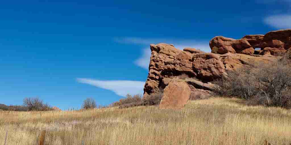
South Valley Park also contains red sandstone rock outcrops from the Fountain formation, an even older layer of sedimentary rock (290 -340 million years old). These older Fountain formation rocks protrude from the valley floor at irregular intervals.
Red rocks from the Fountain Formation are also visible in other nearby parks, such as Matthews/Winters Park, Denver’s Red Rocks Park (the park with the famous outdoor amphitheater), and Roxborough State Park.
History of Land Use in South Valley Park
The original white owner of the park grounds was Frank Mann, who purchased a parcel in 1882, and the privately-owned Mann Reservoir in the park has his name.
John Schaffer’s Ken-Caryl Ranch Company purchased this tract of land in 1926. Although the property subsequently changed owners multiple times, it operated as a cattle ranch until 1980. The north part of the valley then became the Ken Caryl housing development, and JCOS acquired the land of South Valley Park for preservation in 1997.

But the park had been supporting nomadic peoples much before white settlers appeared on the scene. Archeological digs revealed evidence of human occupation from about 10,000 years ago, with most individual items recovered dating to between 5,000-3,000 years ago. Scientists studying the sites believe native Americans used red rock caves as shelters and hunted wildlife that roamed the valley during the colder months.
Today, the park’s plant life, including scrub oak and native grasses, still attracts wildlife to the area, to the delight of hikers.
Hiking in South Valley Park
Trails traverse the valley west of the Lyons Hogback, and access is via either the North or South Trailhead on roughly opposite ends of the park. Locations are below in the custom map. While the Lyons formation stone is sandy in color, red sandstone from the Fountain formation dots the valley.
Venturing off the trail in South Valley Park is strictly prohibited, both for the safety of park-goers and the protection of the sensitive environment. Although it looks robust, the red sandstone is surprisingly vulnerable to erosion.
See descriptions of the individual trails in the next section.
South Valley Park Trails
With only 7.7 miles (12.4 km) of trails, hikes in South Valley Park might be on the short side. On the other hand, the numerous trail connections mean that various routes and loops are possible. The individual trails and their relationships are described below.
Coyote Song Trail

Coyote Song is the backbone of the trail system and traverses the park’s length. It connects the North and South Trailheads over 1.5 miles (2.5 km). There is about 330 feet (100 m) elevation gain overall from the South Trailhead to the North. Most of the climb is near the South Trailhead, where the route is marked as moderate. The remainder of the trail is rated easy.
A branch near the North Trailhead connects with the Valley View Trail and short trails to the picnic areas. The other park paths are connected to the Coyote Song Trail directly (Swallow Tail, Lyons Back, Prairie Falcon) or indirectly (Grazing Elk).
Swallow Tail Trail
Swallow Tail Trail is a hiker-only trail that runs roughly parallel to the Coyote Song Trail for about 0.8 miles (1.3 km), starting at the North Trailhead. The easy trail ends at a T-intersection with the Prarie Falcon Trail.

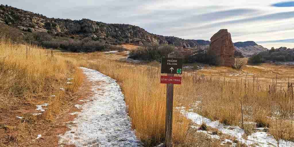
Prairie Falcon Trail
From here, one direction leads back to the Coyote Song Trail. The other direction takes the hiker to the Valley View and Grazing Elk Trails. Pick up the Valley View Trail at S. Valley Road. To get to the Grazing Elk Trail, cross over S Valley Road and continue on the path. Extreme caution is required here, as there are no safety features at this crossing. Both trail segments add up to 0.8 miles (1.4 km).
Grazing Elk Trail
This flat trail is a 2.3 mile (3.7 km) loop. It’s ranked as easy, but it takes a short climb on the Prarie Falcon trail to get up to it. It may feel quieter and have fewer visitors than Coyote Song or Swallow Tail because it’s on the other side of S Valley Rd. from the trailheads.
Lyons Back Trail
Lyons Back is a short (0.2 miles, 0.3 km), steep trail to the top of the Lyons hogback from the Coyote Song Trail. The payoff for this brief effort is an incredible view of the valley below, including a different perspective of the many impressive red sandstone formations jutting up from the meadows. After taking in the scenery, head back down to the Coyote Song Trail or walk down the other side of the ridge to get to other trails outside the park (described below).

View of red sandstone rock formations from the top of the Lyons Hogback on the Lyons Back trail
Valley View Trail
The Valley View Trail is the only paved trail in the park and follows the park border with S Valley Road for 1.4 miles (2.3 km). The trail extends past the park’s boundary on the north side-the total distance is 2.3 miles (3.73 km). It connects to the Prairie Falcon Trail on the south end and the Coyote Song Trail on the park’s north side. This trail also continues outside the park border and can be used to access the C-470 Trail (see below). Frankly, there is little reason to use this trail as the experience and views are much better from the interior, natural surface trails.
Multi-Trail Hikes
Trail combinations can form large loops that increase the overall hiking distance. For example, the AllTrails page for South Valley Park shows several trails combinations with round trip distances ranging from 1.3-15 miles (2-24.1 km).
Other Information for South Valley Park
Both the North and the South trailheads have parking and restrooms. Drinking water is available seasonally at the south trailhead, and the north trailhead also has a picnic area that includes shaded picnic shelters.

The JCOS page for South Valley Park shows real-time parking spot availability. Download the Lot Spot app for details. Also, obtain parking information at other JCOS Lot Spot-enabled parking lots.
There is a little bit of shade near the park’s south end, but most terrain is open to the elements. So assess the weather and be ready with sun protection (hat, sunglasses, appropriate clothing, and sunscreen) on clear days. And don’t forget to hydrate!
South Valley Park Trail connections
South Valley Park has many connections to other parks and trails, described below.
Ken Caryl Open Space Trails
From the top of the Lyons Back Trail, head down the backside of the hogback to intersect the Columbine Trail, which is part of Ken Caryl open space. The Columbine Trail forms a loop with the longer Cathy Johnson Trail, which doubles as a maintenance road. These trails traverse the valley between the Dakota hogback and the Lyons hogback.
To get back into the park from the valley, take the Columbine Trail in the northerly direction, then move onto the Cathy Johnson Trail. At the end of the Cathy Johnson Trail, turn back to the left (southerly) on the Valley View Trail sidewalk, which will take you to either park trailhead. Of course, returning to the top of the hogback via the Lyons Back Trail is also an option.
Note: The Columbine Trail and the Cathy Johnson Trail are the only two trails in the Ken Caryl open space open to the public. Using the remaining trails in the system requires proof of residence or guest status.
Trails Connection with Deer Creek Canyon Park
Deer Creek Canyon Park is another JCOS park with miles of hiking trails, and it’s one of my favorites. To get there, take the Grazing Elk Trail loop to its intersection with the Rattlesnake Gulch Trail. This path crosses over W Deer Creek Canyon Road and continues into Deer Creek Canyon Park with the same name. Use extreme caution when crossing the road–there are no safety features here! This moderate trail (0.9 miles, 1.4 km) ends at the trailhead in Deer Canyon Park.

Connection to the C-470 Trail
The Valley View Trail continues, more or less as a sidewalk north of the Coyote Song Trail. To get to the C-470 trail, take the trail north to the intersection with Ken Caryl Avenue and turn right (east). The pavement takes you to Colorado highway 470, crossing under to get to the paved C-470 trail at the intersection with the off-ramp on the other side. I don’t think there is any reason to walk this route as it’s much more suited for bike traffic.
Custom Trail Map of South Valley Park
I created this map to show all of the trails in the park plus the connecting trails in Ken Caryl open space and Deer Creek Canyon Park.
Red: Coyote Song; Purple: Valley View ; Green: Swallow Tail: Blue: Prairie Falcon; Yellow: Columbine; Red2: Grazing Elk; Blue2: Lyons Back; Green2: Cathy Johnson; Purple2: Rattlesnake Gulch
Don’t see the map or want to see the original? Click here to go to the map page on AllTrails.
Other Trail Information
| Getting There | South Trailhead 12447 Deer Creek Canyon Road Littleton, CO 80127 North Trailhead 8354 South Valley Road Littleton, CO 80127 |
| Distance | Total of 7.7 miles (12.4 km) of trails |
| Difficulty | Easy to moderate, with a 0.2 mile (0.3 km) moderate to difficult climb on Lyons Back |
| Trail Type | Mostly Out and Back with connections for loops Grazing Elk is a loop |
| Trail Surface | Unpaved, natural; one hard surface trail |
| Besides Hiking: | trail running, mountain biking, equestrian |
| Links | Jefferson County Open Space Park System JeffCo Open Space Page for South Valley Park Colorado Trail Explorer (COTREX) PageAllTrails hikes for South Valley Park |
| Closest Towns | Littleton |
Wrapping Up
Tucked behind two hogbacks, the South Valley Park trails pass unusual red rock formations and offer views of lighter-colored Lyons sandstone ridge. A drive of a few minutes from the nearby highway transports you to an open space that feels far removed from nearby strip malls and housing developments. With each step, marvel at geological remnants of mountain-building forces while knowing that this land has been worked and enjoyed by people for thousands of years.
Have you visited South Valley Park? What did you think? Leave a comment below!
Leave a Reply